Strong CME Incoming

ONE DOWN, TWO TO GO: As predicted by analysts at the GSFC Space Weather Lab, the first of three CMEs produced by the recent spate of flare activity reached Earth during the late hours of August 4th. The impact was weak and is not expected to produce strong geomagnetic storms. Two more CMEs are still on the way and, as described below, they may have merged into a single cloud that could produce significant storming when they reach Earth on August 5th at 10:00 UT (plus or minus 7 hours). A new model of all 3 CMEs is now available; stay tuned for updates.

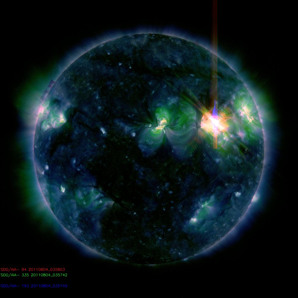
STRONG SOLAR ACTIVITY: On August 4th, active sunspot 1261 unleashed a strong solar flare, the third in as many days. The blast, which registered M9.3 on the Richter Scale of Flares, hurled a bright coronal mass ejection (CME) almost directly toward Earth. Click on the image to view a movie of the expanding cloud recorded by the Solar and Heliospheric Observatory:


Note: The many speckles in this movie are caused by energetic solar protons hitting the camera.

Moving at an estimated speed of 1950 km/s, this CME is expected to sweep up an earlier CME already en route. Analysts at the GSFC Space Weather Lab say the combined-CME should reach Earth on August 5th at 10:00 UTplus or minus 7 hours: “The impact on Earth is likely to be major. The estimated maximum geomagnetic activity index level Kp is 7 (Kp ranges from 0 – 9). The flanks of the CME may also impact STEREO A, Mars and Mercury/MESSENGER.”

fr/spaceweather.com

Typhoon Muifa Threatens China

5 August 2011 Last updated at 10:13 ET

Fishing boats take shelter in the port of Zhou Shan in China's Zhejiang province Thousands of fishing boats have been called back to harbour

China has put parts of its east coast on alert as powerful Typhoon Muifa approaches the country.

Muifa passed Taiwan on Friday and is heading for Zhejiang and Jiangsu provinces, close to Shanghai, saidChina’s Central Meteorological Office.

More than 7,000 fishing boats have been called back to harbour, as winds reached 162km/h (100mph), generating waves of 36ft (11m) out at sea.

Air travel faces disruption and coastal areas are preparing for evacuations.

China Southern Airlines has cancelled more than 140 flights to eastern China from Saturday afternoon while Shanghai-based China Eastern Airlines warned of a “severe impact” on services, reported AFP news agency.

An orange alert has been issued to ships and fishing vessels, China’s second-highest alert level, the meteorological office said.

Typhoon Muifa is expected to make landfall in China on Saturday night or early on Sunday.

to read more, go to:    http://www.bbc.co.uk/news/world-asia-pacific-14420501

NOAA Downgrades Predicted Number of Tropical Storms This Season

NOAA still sees big potential for hurricanes

BY JENNIFER KAY

THE ASSOCIATED PRESS

PENSACOLA, Fla. — Record high ocean temperatures and the development of a climate phenomenon known as LaNiña will keep the Atlantic hurricane season on track to be the busiest since 2005, government forecasters said Thursday.

The National Oceanic and Atmospheric Administration slightly lowered the outlook it released in May, but an above-normal season is still expected, said Gerry Bell, lead seasonal hurricane forecaster at NOAA’s Climate Prediction Center in Washington.

The updated forecast calls for 14 to 20 named tropical storms, down from a range of 14 to 23.

The hurricane season started June 1 and ends Nov. 30, but the peak period for hurricanes runs from August through October.

Eight to 12 storms could become hurricanes, and four to six of those hurricanes could become major storms, with winds of 111 mph or more, forecasters said.

“August heralds the start of the most active phase of the Atlantic hurricane season, and with the meteorological factors in place, now is the time for everyone living in hurricane-prone areas to be prepared,” NOAA Administrator Jane Lubchenco said in a statement.

During active storm seasons, multiple hurricane strikes are much

Read more: http://www.miamiherald.com/2010/08/06/2346383/noaa-still-sees-big-potential.html#ixzz1UANVqUtJ

More on TS Emily

Tropical Storm Emily weakens to barely nothing, still could regenerate

Published on August 4, 2011 8:35 pm PT
– By Kevin Martin – Senior Meteorologist
– Article Editor and Approved – Ron Jackson


Click for larger image

(TheWeatherSpace.com) — Tropical Storm Emily has vanished below Tropical Storm status as the storm interacted with the terrain of Haiti and the Dominican Republic, however it could regenerate.

The center is not closed anymore but that does not mean it will not move over Cuba and then regenerate back into a depression or low grade tropical storm.

The last forecast article stated in quotes that models said hurricane status but I decided to be more realistic and give Florida a weaker system, depression or tropical storm.

to read more, go to:    http://www.theweatherspace.com/news/TWS-08_04_2011_emilyvanishes.html

Earth’s Two Moons?

Earth may once have had two moons

By Matt McGrathScience reporter, BBC World Service

A new theory suggests the Earth once had a small second moon that perished in a slow motion collision with its “big sister”.

Researchers suggest the collision may explain the mysterious mountains on the far side of our Moon.

The scientists say the relatively slow speed of the crash was crucial in adding material to the rarely-seen lunar hemisphere.

Details have been published in the journal Nature.

The researchers involved hope that data from two US space agency (Nasa) lunar missions will substantiate or challenge their theory within the next year.

For decades, scientists have been trying to understand why the near side of the Moon – the one visible from Earth – is flat and cratered while the rarely-seen far side is heavily cratered and has mountain ranges higher than 3,000m.

Various theories have been proposed to explain what’s termed the lunar dichotomy. One suggests that tidal heating, caused by the pull of the Earth on the ocean of liquid rock that once flowed under the lunar crust, may have been the cause.

But this latest paper proposes a different solution: a long-term series of cosmic collisions.

to read more, go to:    http://www.bbc.co.uk/news/science-environment-14391929

Incoming Strong Solar Flare


STRONG SOLAR ACTIVITY: For the third day in a row, active sunspot 1261 has unleashed a strong M-class solar flare. The latest blast at 0357 UT on August 4th registered M9.3 on the Richter Scale of Flares, almost crossing the threshold into X-territory (X-flares are the most powerful kind). The number of energetic protons around Earth has jumped nearly 100-fold as a result of this event.

fr/spaceweather.com

Another Phoenix Haboob

Dust storm rolls through Phoenix overnight, excessive heat continues

by Catherine Holland

azfamily.com

Posted on August 3, 2011 at 6:26 AM

Updated today at 4:54 PM

PHOENIX – Mother Nature took another swipe at the Valley, delivering the fourth major dust storm of the monsoon early Wednesday morning, which was also one of the warmest mornings we’ve seen in some.

The storm slowly rolled across the Valley between 1 a.m. and 3 a.m., leaving dust hanging in the air hours later. Some early morning commuters thought the dusty haze was fog.

While many people might have heard the wind, they didn’t realize another dust storm had hit until they saw the layer of dust on their cars.

The National Weather Service issued a dust storm warning just before 1 a.m. The storm pushed up from the Tucson area through Pinal County and into Phoenix metro area, bringing high winds and lots of dust.

It was mostly over by the time “Good Morning! Arizona” went on the air at 4:30 a.m., but there still was some thunderstorm activity in Pima County, as well as some light shower in Pinal County. That storm activity was dying down as the sun came up.

Because it happened in the middle of the night, it’s difficult to compare the severity of Wednesday morning’s dust storm with the previous three storms.

to read more, go to:    http://www.azfamily.com/news/Dust-storm-rolls-through-Phoenix-overnight-126660458.html

TS Emily Approaches Miami

Tropical Storm Emily still moving west, Miami very near impact zone

Published on August 3, 2011 3:00 pm PT
– By Kevin Martin – Senior Meteorologist
– Article Editor and Approved – Ron Jackson


Click for larger image

(TheWeatherSpace.com) — Tropical Storm Emily is still moving due west despite the projected path of northwest from NOAA and this might be the key to where it goes.

Right now the storm is moving west, just below the Dominican Republic. NOAA forecasts have the system starting out moving northwest and this will be what the mistake will be on their side.

The storm track on the National Hurricane Center’s track starts out going northwest when the storm is clearly moving west. This error means their track will need to be shifted west.

I’ve kept a western track and even my track is starting to move a bit west, putting Miami at risk for this system to get near or even impact plans over the weekend.

As of now my track has Emily going over the Western Haiti Peninsula in a west-northwest movement. After that it goes over Eastern-Central Cuba before exiting into the Bahamas.

The global models want to keep this well east of Florida but there are key ingredients the models may be missing in the calculations. The placement and strength of the upper level ridge is one of them.

to read more, go to:   http://www.theweatherspace.com/news/TWS-08_03_2011_emilymiami.html

A Tribute to Environmentalists

Worth Dying For

A video tribute to those who have sacrificed their lives to protect the environment.
 Filmmaker Vivek Chauhan created this video celebrating the beauty and diversity of Earth’s natural systems. The video also reveals the man-made dangers threatening those systems, and honors environmental advocates from around the world who have died to protect the places they loved from destruction.
Check out this link to view the video of our Incredible, Living, Beautiful, and Threatened Gaia, our  Home Planet:     http://www.yesmagazine.org/planet/worth-dying-for


Another Earthquake in Ethiopia

Moderate earthquake hits Ethiopia

Last update: August 3, 2011 at 2:52 pm by By Armand Vervaeck and James Daniell


UPDATE: A potentially dangerous earthquake has hit on the border of Ethiopia and Somalia, early this morning. The earthquake would have been very much felt in the city of Borama and villages nearby.


The USGS has its epicenter directly under Borama.


The huge difference in the estimates of GFZ and USGS show the deficiency of adequate seismological stations in this area of the world (similar to our PNG article).


There are no volcanoes in the immediate vicinity according to CATDAT, so this is most likely a tectonic earthquake in the East Africa rift zone.


A number of earthquakes have occurred in this region previously in 1930, 1951, 1961 and 1980.

to read more, go to:    http://earthquake-report.com/2011/08/03/m5-5earthquakehitsethiopia