Tropical Storm Lee is marching steadily northwards towards landfall in Louisiana, and continues to slowly intensify. The storm’s central pressure is now down to 993 mb, as measured by an Air Force hurricane hunter aircraft at 7am CDT. However, the center of Lee is now very close to the coast, and the storm doesn’t have much time to intensify further before the center moves over land. The main impact from the storm on the coast thus far has been heavy rains. At
New Orleans Lakefront Airport, 5.88″ inches of rain had fallen from Lee as of 8 am CDT this morning. Top winds were 35 mph, gusting to 55 mph. Though Lee’s top winds are rated as being 60 mph, it is difficult to find any land stations that have reported sustained winds of tropical storm force, 39 mph or greater. One station that has is at the tip of the Mississippi River Delta, where
Southwest Pass measured sustained winds of 40 mph, gusting to 58 mph, at 7:03 am CDT. Upper-level winds out of the southwest are creating a moderate 10 – 20 knots of
wind shear over Lee, keeping the storm’s heavy thunderstorms pushed to the east side of the storm. Latest
satelllite loops show Lee is becoming increasingly organized.
 Figure 1.
 Radar-estimated rainfall from Lee from the New Orleans radar. Lee has dumped a large region of 4 – 8 inches so far (orange colors.)

Figure 2. Predicted rainfall for the 5-day period ending at 8 am EDT Thursday Sep 8, 2011. Lee is expected to bring a large swath of 4+ inches of rain all the way to New England. Image credit: NOAA/HPC.
Forecast for Lee
Lee’s large size, ill-formed circulation center, and the presence of dry air on its west side due to an upper-level trough of low pressure make Lee look a lot like a subtropical storm on satellite imagery, with a broad center and the majority of the heavy thunderstorms in a broad band well removed from the center. Subtropical storms can undergo only relatively modest rates of intensification, and Lee is unlikely to become a hurricane. Also tending to slow intensification will be the fact that much of its circulation is over land. Damages from Lee are likely to be less than $100 – $200 million, with the greatest threats being fresh water flooding from heavy rains. Given that much of the region Lee will traverse over the next few days is under moderate to severe drought, the storm’s rains may cause more economic benefit than damage. Since Texas is on the dry side of the storm, that state will see very little rainfall from Lee, except very close to the border with Louisiana. The rains from Lee appear to have mostly ended across extreme southern Louisiana, so the feared 10 – 15 inches of rain does not look like it will materialize there. One possible concern for Lee’s rains will be the mid-Atlantic and Northeast, where recovery efforts from the devastating flooding due to Hurricane Irene may be hampered by the additional 2 – 4 inches that may fall from Lee’s remnants by the middle of the week.Tornadoes from Lee are potential hazard today, as NOAA’s Storm Prediction Center is highlighting the Northern Gulf Coast in their “slight risk” area for severe weather. A tornado watch is posted for the region, but no tornadoes have been reported as of 8 am CDT.
Lee is the 12th named storm this year, and came eight days before the half-way point of the Atlantic hurricane season. Climatologically, September 10 marks the half-way point. A typical hurricane season has just 10 – 11 named storms, so we’ve already had more than a whole season’s worth of storms before reaching the half-way point. At this rate, 2011 will see 24 – 26 named storms, making it the 2nd busiest season on record, behind 2005. Lee’s formation date of September 2 puts 2011 in 5th place for earliest date of arrival of the season’s 12th storm. Only 2005, 1995, 1936, and 1933 had an earlier 12th storm.
Hurricane Katia
The latest set of model runs show very little change in the outlook for Hurricane Katia. Katia will continue its long trek across the Atlantic Ocean, and will not pose a danger to any land areas over the next five days. Katia is still struggling with dry air and wind shear that has risen to a high 20 – 25 knots. Latest satellite loops show a lopsided hurricane that is suffering from the impacts of dry air and wind shear on its southwest side.

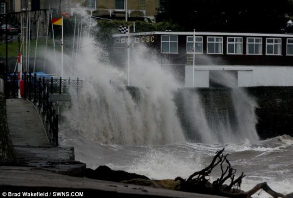 Battered: A large wave hits the sea front at Clevedon, Somerset, today as the tail end of Hurricane Katia struck the UK’s coastline

