A Hole in the Sun

Spacecraft Sees Giant ‘Hole’ In the Sun (Video)

SPACE.com

Megan Gannon
Spacecraft Sees Giant 'Hole' In the Sun (Video)
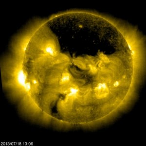
A space telescope aimed at the sun has spotted a gigantic hole in the solar atmosphere — a dark spot that covers nearly a quarter of our closest star, spewing solar material and gas into space.

The so-called coronal hole over the sun’s north pole came into view between July 13 and 18 and was observed by the Solar and Heliospheric Observatory, or SOHO. NASA released a video of the sun hole as seen by the SOHO spacecraft, showing the region as a vast dark spot surrounded by solar activity.

Coronal holes are darker, cooler regions of the sun’s atmosphere, or corona, containing little solar material. In these gaps, magnetic field lines whip out into the solar wind rather than looping back to the sun’s surface. Coronal holes can affect space weather, as they send solar particles streaming off the sun about three times faster than the slower wind unleashed elsewhere from the sun’s atmosphere, according to a description from NASA.

“While it’s unclear what causes coronal holes, they correlate to areas on the sun where magnetic fields soar up and away, failing to loop back down to the surface, as they do elsewhere,” NASA’s Karen Fox at the agency’s Goddard Space Flight Center in Greenbelt, Md., explained in an image description.

These holes are not uncommon, but their frequency changes with the solar activity cycle. The sun is currently reaching its 11-year peak in activity, known as the solar maximum. Around the time of this peak, the sun’s poles switch their magnetism. The number of coronal holes typically decreases leading up to the switch.

After the reversal, new coronal holes appear near the poles. Then as the sun approaches the solar minimum again, the holes creep closer to the equator, growing in both size and number, according to NASA.

The $1.27-billion (1 billion euros) SOHO satellite was launched in 1995 and is flying a joint mission between NASA and the European Space Agency (ESA). It watches solar activity from an orbit about the Lagrange Point 1, a gravitationally stable spot between Earth and the sun that is about 932,000 miles (1.5 million kilometers) from our planet.

from:    http://news.yahoo.com/spacecraft-sees-giant-hole-sun-video-153040642.html

Targeting GMO Activists

As always, do your research.

New Investigation Alleges US Military, Monsanto Targeting GMO Activists and Independent Scientists

Captures

29th July 2013

By Sayer Ji

Contributing Writer for Wake Up World

A highly concerning new investigative report from the largest daily newspaper in Germany alleges that Monsanto, the US Military and the US government have colluded to track and disrupt both anti-GMO activists and independent scientists who study the adverse effects of genetically modified food.

As revealed by Sustainable Pulse, on July 13th the German newspaper Süddeutsche Zeitung detailed information on how the US Government “advances the interests of their corporations,” focusing on Monsanto as a prime example.

The report titled, “The Sinister Monsanto Group: ‘Agent Orange’ to Genetically Modified Corn,” described a ‘new fangled cyber war’ being waged against both eco-activists and independent scientists by supporters and former employees of Monsanto, who are described as “operationally powerful assistants” and who have taken up sometimes high ranking posts in the US administration, regulatory authorities, and some of whom have connections deep within the military industrial establishment, including the CIA.

Monsanto contacts are known to the notorious former secret service agent Joseph Cofer Black, who helped formulate the law of the jungle in the fight against terrorists and other enemies. He is a specialist on dirty work, a total hardliner. He worked for the CIA for almost three decades, among other things as the head of anti-terroism. He later became vice president of the private security company Blackwater, which sent tens of thousands of soldiers to Iraq and Afghanistan under US government orders.”

“Thanks to Snowden and Wikileaks, the world has a new idea of how these friends and partners operate where power and money are concerned. The whistle-blowing platform published embassy dispatches two years ago, which also included details about Monsanto and genetic engineering.”

“For example, in 2007, the former US ambassador in Paris, Craig Stapleton, suggested the US government should create a penalties list for EU states which wanted to forbid the cultivation of genetically engineered plants from American companies. The wording of the secret dispatch: “Country team Paris recommends that we calibrate a target retaliation list that causes some pain across the EU.” Pain, retaliation: not exactly the language of diplomacy.”

The report details the case of Australian scientist Judy Carman, whose work on GMOs underwent heavy criticism by Monsanto supporters. Soon sites that published her work were attacked by hackers with apparent military connections:

Hackers regularly target various web pages where Carman publishes her studies and the sites are also systematically observed, at least that is the impression Carman has. Evaluations of IP log files show that not only Monsanto visits the pages regularly, but also various organizations of the U.S. government, including the military. These include the Navy Network Information Center, the Federal Aviation Administration and the United States Army Intelligence Center, an institution of the US Army, which trains soldiers with information gathering. Monsanto’s interest in the studies is understandable, even for Carman. “But I do not understand why the U.S. government and the military are having me observed,” she says.

The report went on to describe the ongoing though mostly failed crusade of the United States, seemingly on behalf of Monsanto, to open up the European Union’s markets to genetically engineered food and feed crops. According to the report:

“The USA is hoping that negotiations started this week for a free-trade agreement between the USA and the EU will also open the markets for genetic engineering.”

The Americans want to use the Free Trade Agreement to open the European GMO Market. The negotiations will be detailed. Toughness will rule the day. US President Barack Obama has therefore appointed Islam Siddiqui as chief negotiator for agriculture. He has worked for many years for the US ministry of agriculture as an expert. However, hardly anyone in Europe knows: From 2001 to 2008, he represented CropLife America as a registered lobbyist. CropLife America is an important industry association in the United States, representing the interests of pesticide and gene technology manufacturers – including of course Monsanto. “Actually, the EU cannot accept such a chief negotiator because of bias”, says Manfred Hausling, who represents the Green Party in the EU parliament.

If this report is accurate, we can assume that Monsanto has so thoroughly populated both the government and military industrial complex with its own supporters that any remaining illusion of there being a division of Corporation and State has now been dispelled.  Worse, we are bearing witness to the preeminence of the Corporation over State, the very definition of a corpocracy.

from:    http://wakeup-world.com/2013/07/29/new-investigation-alleges-us-military-monsanto-targeting-gmo-activists-and-independent-scientists/

July 29 — Grand Sextile

The Grand Sextile and the Planetary Energies of Transformation

Grand Sextile 2013

29th July 2013

By Kate Knodel

Guest Writer for Wake Up World

On July 29, 2013, a powerful planetary alignment – a very rare Grand Sextile will form in the skies above us. It follows weeks of an unusual and powerful Grand Trine in Water signs involving three planetary giants — Saturn, Jupiter (now conjunct Mars), and Neptune.


grand-trine exampleWhen the Moon moves into position at about 1pm EDT, a second Grand Trine in Earth signs (involving the Moon, Venus and Pluto) will form and activate a Grand Sextile, a rare aspect pattern formed by two Grand Trines with six planets moving into position around the dial at 60* from each other (pictured above).

Trines bring ease of energy flow and sextiles bring opportunity. A Grand Sextile points to harmonious relationships among the energies symbolized by the planets in the pattern.

This Grand Sextile creates what is commonly known as a “Star of David” and will be with us for about 7 hours until the Moon, which travels quickly through our skies, moves off. The pattern symbolizes the harmonious union between masculine and feminine and involves the two feminine elements, Water (highlighting emotion) and Earth (highlighting physicality), as well as both of the major feminine planets, Venus and the Moon. It has been called by some “The Return of the Divine Feminine Grand Sextile.”

t-square exampleWhat makes this day interesting, though, are the two T-squares and a Yod that appear in the solar system along with the Grand Sextile.  T-squares are often challenging energy patterns that create dynamism in the energies symbolized by the planets involved in the aspect pattern.  They are created by two squares and an opposition. A square brings conflict and an opposition brings confrontation as the energies of the two planets mirror each other and reflect qualities that, when confronted, bring about growth.

Yod exampleA Yod, also called “The Finger of God,” is an interesting aspect that includes both challenging and supportive elements which create opportunity for laser-focused action in a particular area of life. In this case, Pluto and Neptune afford the opportunity to shine out from our center (Sun in Leo) in whatever area of life (house) Leo falls in your natal chart.

When I study a chart, the first thing I do is sit with the image and see how it comes up off the page — that tells me so much about the energy of the chart. The image of this Grand Sextile is simply exquisite. A perfect hexagon holds two opposing equilateral triangles and four rectangles move beyond the spaces created by the points of the star. When meditating with the image, I see movement in the form, beautiful, free-flowing energy swirling around the center — the Earth upon which we stand.

So, what are the potentials for this pattern? What are the energies coming together in these trines?

Simply put – breakthrough, and the opportunity to step across a threshold from one way of being into another. Saturn in Scorpio has the potential for intense, private, and deep truth, discipline, and boundaries. Neptune in Pisces invites poetic and imaginative creativity, spirituality, and dreaming. Jupiter/Mars in Cancer will make everything bigger, more expansive, more generous and active, courageous, strong, and passionate in nurturing and emotionally-connected ways. This is a soft place for Jupiter and Mars to fall. Pluto in Capricorn has the potential for transformation around structures and stepping into our power in structured and disciplined ways. Venus in Virgo invites us to bring in love, art, and beauty in discriminating and healing ways. And the Moon in Taurus allows us to attract sensual, loyal, and practical energies in order to ground all the other energies.

The T-squares add a significant bit of turbulence and an incredible amount of dynamism to the chart. Without the T-squares, the day would promise to be a little unreal. The T-squares make it a very human day. They promise to both ground us in reality and sweep us away into the storms they create.

A paradox?  Certainly. The chart points very much to paradoxical energies.

The Moon in Taurus is opposite Saturn and both are square the Sun in Leo. On a day that promises harmonious union between masculine and feminine, the chief symbols for the masculine and feminine are in conflict in ways that might create restriction and constriction. On the light side, it could lead to a deeper sense of truth. Pluto is opposite the Mars/Jupiter conjunction and both are square Uranus in Aries. The Pluto-Uranus square that has been such a big player in the solar system for the last year also has a role in Monday’s aspect pattern. That, in relationship with the Mars/Jupiter conjunction will strengthen and expand the energy. And, somehow, all this will dance with all those lovely trine and sextile energies.

In reading what others have written about the planetary energies for July 29, so many of us are coming to similar understandings of this time — an incredible time of opportunity and energies that encourage us to step forward into our creativity, truth, and power. Still, the challenges of transformation continue.

micro macroAt times I find myself simply closing my eyes, breathing, and allowing the waves of whatever all this energy is to just pass through me. As I have been studying the chart for Monday, and the Grand Sextile, I am feeling energetic storm energy and seeing each of us needing to be grounded, with Earth – Gaia – in the center, the still eye of the storm. As above so below. Yes, we are mirroring these energies. Macrocosm and Microcosm.

I think part of what will be key is not judging the energy, which is one reason why I think the deepest wisdom is not to analyze the chart by  trying to “figure it all out” but just being with the energy, just being still, the eye, as the energies swirl. It is liminal time, threshold time — as is the energy.

I feel affirmed in this impression by what is not in the chart. There are no major planets in the air signs — Libra, Gemini, or Aquarius, which are associated with thinking and intellect. This tells me that it is not a day to be up in our heads. It’s a day to sink into our hearts and allow ourselves to be deeply in our bodies. This will help us to manage the ejections of fire that will come with the T-squares and Yod, as well as any temptation to over-think. And as many of these aspect patterns will continue for some days, it may be something to “keep in mind” as we move through the week.

Key to astrology symbols:

key

About the author:

Katherine Cartwright KnodelKate Knodel is an explorer of the landscape of poetry, myth, and our fractured, expanding and healing selves. She is a speaker and workshop leader, writer, astrologer, empowerment coach and transformational training designer.

from:    http://wakeup-world.com/2013/07/29/the-grand-sextile-and-the-planetary-energies-of-transformation/

Latest on Schrodinger’s Cat

Bizarre ‘Schrodinger’s Cat’ Comes Alive in New Experiments

Jesse Emspak, LiveScience Contributor   |   July 22, 2013

an illustration of the quantum teleportation of 'Schrodinger's Cat' wave packets of light from a past physics study.
New research bolsters the validity of Schrodinger’s Cat, a thought experiment suggesting a cat can be both alive and dead at the same time. (Shown here, an illustration of the quantum teleportation of ‘Schrodinger’s Cat’ wave packets of light from a past physics study.)
Credit: Image courtesy of Science/AAAS

The strangeness of the world of the very small that allows a particle to be in two states at once may extend to larger scales, two new studies reveal. If the research proves true, that would bolster the validity of a thought experiment suggesting a cat can be both alive and dead at the same time.

The idea, called Schrödinger’s Cat after the physicist,Erwin Schrödinger, who proposed it in 1935, goes like this: Put a cat in a box with a vial of poison gas. The vial opens when a tiny piece of radioactive metal emits an alpha particle (the nucleus of a helium atom) as it decays. Emitting an alpha particle is a quantum-mechanical process, which means that whether it happens in any given stretch of time is basically random.

Quantum mechanics says that it’s impossible to know whether the radioactive decay has happened (and the cat is dead) unless one measures it — that is, unless the alpha particle interacts with the environment in some way that an observer can see. Until that happens, the alpha particle is emitted and not emitted at the same time. The cat is both dead and alive, a state called superposition. Opening the box is a measurement — one sees the effect of an alpha particle as the dead cat, or the absence of an alpha particle as a live one.

In the two new studies, detailed in the July 21 issue of the journal Nature Physics, researchers used particles of light, or photons, to test the limits of such superposition. If there is no limit to how many particles or photons you can put into a quantum system, that means the cat really is both dead and alive at once, and the act of measuring its state makes the mathematical formulation that describes it (called a wave function) “collapse” into a definite state, alive or dead.

Another possibility, called the many worlds interpretation, would be even weirder: that all the possible states are real, and when the wave function collapses to one state, we’re just experiencing one of many universes that exist simultaneously, in which every possible outcome happens. When the wave function collapses, we (and the cat) remember one history — a dead cat — but there’s another universe where the cat is alive.

Entangling photons

Both experiments, one conducted at Canada’s University of Calgary and the other at the University of Geneva in Switzerland, involved enough photons to be seen with the naked eye, which shows that their quantum properties could be made macroscopic, researchers say.

In the two experiments, researchers measured the quantum states — a group of physical properties, including polarization and phase — of the light using polarization, or the angle through which a photon rotates. One can see polarization while wearing polarized sunglasses and tilting one’s head while looking at the screen of a smart phone or computer. The screen will look black until the head is tilted at a certain angle.

While the exact technique was slightly different in the two experiments, both teams amplified the states of a single photon, entangling it with many other photons, and then restored it to its original state. When a photon gets entangled with other photons the state of the photon is affected by the states of the particles it is entangled with.

The polarization measurements after restoration told the researchers that the quantum entanglement with other photons had happened.

The scientists are now trying to see how large a quantum system can get before it loses its quantum nature. “It’s one of the few big unanswered questions in modern physics,” said Alexander Lvovsky, a professor of physics and lead author of the University of Calgary paper.

Superposition states

The new experiments aren’t the only ones to show superposition states.

In 2010 scientists at the University of California, Santa Barbara built a resonator — basically a tiny tuning fork — the size of the pixel on a computer screen, and put it into a superposed state, in which it was both oscillating and not oscillating at the same time. But that wasn’t as extensive a system as those in the two recent papers.

“That experiment corresponds to one quanta,” said Nicolas Gisin, a professor at the University of Geneva, who led the Swiss research team. “Imagine a nano-mechanical motor showing no oscillation and 500 states. That would be ours.”

In the future, both groups will try to expand to bigger systems, where instead of translating a quantum state from a single photon to a large set of photons, they will try to translate the states of one large group to another. But that experiment will be a tough one, because in order to preserve quantum effects, groups of atoms or photons must be completely isolated from the surrounding environment, or the superposition states will be spoiled. “There are a lot more angles of attack,” with more particles, Lvovsky said.

from:    http://www.livescience.com/38339-experiments-bolster-schrodingers-cat-idea.html

Siberia heat Wave, South America Cold, Thailand Rains

Cold Snap hits southern South America. UPDATE: (and ‘Big Fish in Living Room’ story!)

It has been a wild week for temperature extremes with the amazing heat wave in north central Siberia juxtaposed with an unusual cold spell in portions of Brazil, Bolivia, and Argentina occurring simultaneously almost exactly opposite one another on the planet. Scroll down to end of blog for my fishy story! It actually has some context considering the amazing rainfall record set at Chantaburi, Thailand this past week.

South American cold snap

Between 20-25th July a mass of very cold air suddenly froze a large area of southern South America (where temperatures had been running above average for weeks prior to the abrupt change).

Snow was recorded for the first time since 1996 at Catamarca, Argentina (28°S and located at about 500m/1,650’), and cold rain (temperatures of 5-6C/41°-43°°F) at sea level altitudes like Florianopolis, Brazil. Montevideo, Uruguay also experienced rain with temperatures as low as 3C (37°F). The town of Campos Novos, Brazil (at an elevation of 947m/3,100’) had a high temperature of just 3.6°C (38.5°F) and low of -2.7°C (27.1°F) on July 23rd, a daily average of almost freezing (0.9°C/32.8°F). There was no precipitation at the site that day, if so it probably would have been snow. In fact, a little snow was reported in Brazil in the hills above nearby Curitiba for the first time since 1975.

Snowfall in the mountainous region of Santa Catarina, Brazil is not so unusual. Above is an image of a deep snowfall near Rio Grande do Sul during the cold wave of July-August 2010. Ironically, this occurred at the same time as the famous Moscow heat wave of that summer, a somewhat similar situation as is now occurring. Photographer not identified.

There were incredible temperature contrasts in Bolivia (which isn’t unusual given the complex Andean topography) but what was unusual was that it was actually colder at the low elevations in the Amazonian jungle than in the higher mountainous terrain of the country: temperatures at Bolivian locations above 4000m (13,000’) on 23 July were higher than those in the Bolivian portions of the Amazon jungle at low elevations. For instance, the temperature at Reyes (located at 14°S and 140m/462’ elevation) had a maximum of 9.3C/48.8°F while at El Alto Airport, La Paz (elevation 4,000m/13,200’) the temperature maximum reached 13.9°C (57°F). Temperatures in the Chaco region of Bolivia were remarkably chilly with a reading of -5.8°C (21.6°F) observed at Villamontes.

Some places in the middle of the Andes, protected by mountains on all sides, like Cochabamba didn’t experience a single degree drop in temperature, while low areas experienced drops as high as 22-25°C (40-45F) in 24 hours. In Paraguay sleet was recorded in Itapua and the minimum temperature reached -5.2C (21.6°F) at Prats Gill on 24th, not far from the all-time national record of -7.5C (18.5°F) (also set in Prats Gil) on July 13, 2000

The cold air actually filtered as far north as the western part of the Amazon jungle near the Equator, with 7°C (44.6°F) at Rio Branco, Brazil (10°S latitude) and 16°C (60.8°F) at Leticia, Colombia (4°S latitude). Both are low-level sites in the Amazon Basin.

The most exceptional cold wave, in regard to how north cool air has ever penetrated, was that of July 1975 when air of polar origin reached the Caribbean affecting the whole of South America (including the extreme western part of Amazon in Peru, Brazil, Colombia, Venezuela, the Guyanas, and even Trinidad and Tobago. Unlike other cold waves (such as those of 1955, 1973 and 2010) the July 1975 event didn’t stop south of the Equator, but continued well into the Northern Hemisphere. This remains unique and the only documented occurrence of such an event. The surface high pressure reached 1044 hPa (30.82”) over central South America on July 15, 1975, the highest yet measured (modern records) on the continent (REF: Markgraf, Vera Interhemispheric Climate Linkages p. 37)


500 mb MAP

Surface air temperature anomaly for the week of July 19-24 (top map) and 500 mb height anomalies for the same period (bottom). Note how the cold air over South America is almost exactly on the opposite side of the world from the heat dome over north central Siberia. NCEP/NCAR maps, courtesy of Stu Ostro.

The cold snap this past week was caused by a strong upper-level low centered over the southern third of the continent. Curiously, it has been unusually mild over the portions of Antarctica opposite South America with a high of 7.8C (46.0°F) being recorded at Base Esperanza (63°S), higher than the normal summer average maximum and just 1.5°C less than the Amazonian maximum of Reyes in Bolivia at 14°S latitude!

Meanwhile on the other side of the world…

The unrelenting heat wave in north central Siberia continues with Svetlogorsk (on the Arctic Circle) recording its 13th consecutive day (as of July 26) with temperatures above 30°C (86°F). Meanwhile, all eyes are turning to Western Europe where a potentially historic heat wave is expected to develop this weekend and continue into next week! There is a chance that some all-time national heat records may fall in some countries like Germany, Liechtenstein, Austria, Slovakia, Slovenia, and Hungary when all is said and done.

Phenomenal Rainstorm in Thailand

On a side note, a historic rainstorm has caused serious flooding in portions of southeastern Thailand. Chantaburi picked up 445.7mm (17.55”) of rain on July 23rd with an amazing 385mm (15.16”) of this falling in just 12 hours and an even more amazing 297 mm (11.69”) in just 6 hours! This may be one of the (if not the) heaviest 24-hour rainfall on record for Thailand (previous record was 414.8mm (16.33”) at Ko Samui on March 28, 2011. A famous flood in Bangkok occurred on May 9-10, 1986 when 401.1 mm (15.79”) of rain fell in just 8 hours. The ensuing floods almost cost the mayor (Chamlong) his job.

My ‘fish story’

I lived a few blocks from the Bangkok Met office at the time (during the storm of 1986) on Soi 49 Sukhumvit Rd. and caught a 15″ fish that swam through a break in the screen porch door off my living room which flooded about half a meter deep at one point. My girlfriend at the time and I trapped the sucker hiding under the water-logged couch in the living room. We grilled it later that same day (after the water receded) and it was delicious (no idea what kind of fish it was). I think I must be one of the only people who have caught a large live fish swimming around their living room and then cooked it in their kitchen just 10 feet away hours later :-). I’d love to hear from other WU friends if they have had a similar experience!

METARS for Chantaburi, Thailand July 22-23 when a peak 24-hour rainfall amount of 445.7 mm (17.55”) accumulated, a possible national record. Flooding continues as more rain has since fallen over this region of southeastern Thailand. From OGIMET.

KUDOS: Thanks to Maximiliano Herrera for much of the above information about the cold wave in South America.

Christopher C. Burt
Weather Historian

from:    http://www.wunderground.com/blog/weatherhistorian/show.html

TS Dorian, TS Flossie, European Heat Wave,

In the Central Pacific, Tropical Storm Flossie, a strong tropical storm with 65 mph winds, is headed west at 20 mph towards Hawaii. Satellite images show that Flossie is maintaining a modest area of heavy thunderstorms that are well-organized. The storm is over waters of 25°C, which is about 1°C below the water temperature typically needed to sustain a tropical storm. Flossie peaked in intensity Saturday morning, when the storm had 70 mph winds. As Flossie approaches the Big Island of Hawaii on Monday, these waters will warm to 26°C, but wind shear is expected to be in the moderate range, which should keep Flossie from strengthening. Dry air aloft will likely cause some weakening before landfall Monday morning, and Flossie will likely have top winds of 45 – 55 mph when is passes through the Hawaiian Islands. Flossie’s main threat will be heavy rains, with 6 – 10″ expected over The Big Island and Maui County, and 4 – 8″ in Oahu. Rains of this magnitude are capable of causing dangerous flash flooding and mudslides. Sunday’s 11 am EDT wind probability forecast from the Central Pacific Hurricane Center gave Hilo on the Big Island a 33% chance of experiencing sustained tropical storm force winds of 39 mph or greater from Flossie. These odds were 32% for Honolulu and 41% for Kahului.


Figure 1. MODIS satellite image of Tropical Storm Flossie taken at approximately 5 pm EDT Saturday July 27, 2013. At the time, Flossie had top winds near 50 mph. Image credit: NASA.

Tropical storms are uncommon in Hawaii
On average, between four and five tropical cyclones are observed in the Central Pacific every year. This number has ranged from zero, most recently as 1979, to as many as eleven in 1992 and 1994. August is the peak month, followed by July, then September. Tropical storms and hurricanes are uncommon in the Hawaiian Islands. Only eight named storms have impacted Hawaii in the 34 year period 1979–2012, an average of one storm every four years. Since 1949, the Hawaiian Islands received a direct hit from just two hurricanes–Dot in 1959, and Iniki in 1992. Both hit the island of Kauai. Only one tropical storm has hit the islands since 1949–an unnamed 1958 storm that hit the Big Island. A brief summary of the three most significant hurricanes to affect Hawaii in modern times:

September 1992: Hurricane Iniki was the strongest, deadliest, and most damaging hurricane to affect Hawaii since records began. It hit the island of Kauai as a Category 4 on September 11, killing six and causing $2 billion in damage.

November 1982: Hurricane Iwa was one of Hawaii’s most damaging hurricanes. Although it was only a Category 1 storm, it passed just miles west of Kauai, moving at a speed of nearly 50 miles per hour (80 km/h). Iwa killed one person and did $250 million in damage, making it the second most damaging hurricane to ever hit Hawaii. All the islands reported some surf damage along their southwest facing shores, and wind damage was widespread on Kauai.

August 1959: Hurricane Dot entered the Central Pacific as a Category 4 hurricane just south of Hawaii, but weakened to a Category 1 storm before making landfall on Kauai. Dot brought sustained winds of 81 mph with gusts to 103 mph to Kilauea Light. Damage was in excess of $6 million. No Dot-related deaths were recorded.


Figure 2. Tracks of all tropical storms and hurricanes to pass within 100 miles of the Hawaiian Islands, 1949 – 2012. During that time span, the Hawaiian Islands received a direct hit from just two hurricanes–Dot in 1959, and Iniki in 1992. Both hit the island of Kauai. One tropical storm also hit, and unnamed 1958 storm that hit the Big Island of Hawaii. Image credit: NOAA/CSC.

Remains of Dorian are worth watching
The remains of Tropical Storm Dorian will be passing just north of northern Lesser Antilles Islands today and just north of Puerto Rico tonight. Satellite images show no signs of a surface circulation, and just a moderate area of heavy thunderstorms associated with the storm. AIr Force hurricane hunter aircraft are on call to investigate Dorian’s remains on Sunday afternoon and Monday afternoon, if necessary. In their 8 am EDT Tropical Weather Outlook, NHC gave Dorian’s remains a 20% chance of regenerating by Tuesday.

Extreme heat wave in Europe
An extreme heat wave is baking Europe today, and at least five countries have a chance at setting a new all-time national heat record. The most likely candidate is Liechtenstein, where the forecast for Balzers Sunday calls for a high of 95°F. According to wunderground’s International Records database maintained by our weather historian, Christopher C. Burt, the current all-time heat record for Liechtenstein is 36°C (96.8°F) set at Vaduz on August 13, 2003.

from:    http://www.wunderground.com/blog/JeffMasters/show.html

Your Color Vibe for 07/27

Saturday, July 27:
Okay, it is time to give up a lot of the stuff that you had been counting on, and to see it for what it is/was.  These things are pretty well rooted in your past dreams, desires, and expectations.  They have no more real import as the energies are shifting and changing.  If you are to hold onto them, you can find yourself being really, really frustrated, and frustration can meld into anger if it is not nipped in the bud.  So today is about taking a look at that old stuff that you had once thought was so important.  It is about seeing the competitions, the encounters, the happenings, real, imagined, or dreamt about, for what they are and knowing that  they were merely things that you thought were important then.  Then was a big word then.  NOW is the new word.  Let all of that then stuff go, and open to the NOWness of what is all around you.  Now is today, and today is showing you a few things that you need to look at.  How you will deal with them, receive them, open to them is up to you.  Throughout it all there is always choice

Jim Self on Time

Passing Through Present-Time

Jim Self
a message from Jim Self
Tuesday, 16 July, 2013  (posted 25 July, 2013)

As you move through your days, do you notice that your relationship with time has changed? First of all, there seems to be less of it. And what little remains is jam packed with commitments and obligations. In a very real sense, many are moving from the past into the future without even a glance at the present moment.

We are leap-frogging over the present to get to the future as we drag our past along. Business travel offers a tremendous opportunity to observe your relationship with time and where you are at every moment. As you rent the car, are you thinking about directions to the hotel (future), and in that unfocused moment misplace your driver’s license and have to go out of your way to retrieve it? As you check into the hotel, are you reminded of another (past) stay and forget to ask for a king-size bed?

Even in our personal lives, we rush through the present from the past into the future. As you check your email, is your attention on the conversation with your partner an hour ago? As you prepare your meal, are you focused upon it or is your attention on finishing up your taxes after dinner? Keeping your attention in the past or future can, at the very least, be stressful. Long term attention on the past or future can cause an imbalance in your present-time experience and your ultimate success, ease and well-being.

James attended a Level 1 seminar in Toronto, Canada. He was enthusiastic and ready to make changes in his life. He was also not in present-time. James asked many, many questions. Non-stop. Most of his concerns and questions were based upon experiences from the past (childhood injuries, lost relationships, unsatisfying career) and worries about the future (money, new town, his heath). The moment I answered one question, he had three more flowing out of his mouth.

He didn’t hear the answers and had his full attention on a time other than the present. Only after frequently and gently being reminded to ground and bring his attention back to the present moment did James take a breath and slow down. (“All your questions will indeed be answered, I promise. The answers lie exactly where the question is asked.”) By the end of the weekend he was quiet, in his body (pain-free), present, and saying he was the calmest he had been in a very long time.

Present-time is the only place from which you can successfully create, whether you are creating a day at the beach or a business meeting.  Your body is in the present – right here and now.  Keeping your attention with your body, instead of the past or future will allow greater health, well-being, success, and laughter.  The only way to solve a problem is from the present.  When you misplace your driver’s license at the airport, the only way you will know how to proceed is from the grounded present.

Self-Coaching Tool

Before you are in the thick of a stressful situation practice using your tools. If you practice them when you don’t need them, you’ll have them at your fingertips when you do. Try asking yourself one of these questions as often as possible during each day for a wonderful time-check:

“What thought am I thinking right now?”  (going shopping, the meeting we just completed, my kid at home)

“Where am I?: – Past, future or present? In my body?

“How did I get here?”  Try to trace back the (unconscious?) thought-path that got you here.

Asking yourself these three questions will bring your attention and your energy back to the powerful, present moment from which ease and success flow. The Grounding Cord tool and the Center of the Head tool will also help tremendously.

Universal Copyright 2013 is authorized here. Please distribute freely as long as both the author and www.masteringalchemy.com is included as the resource and this information is distributed on a non-commercial
no charge basis.
from:    http://spiritlibrary.com/jim-self/passing-through-present-time

Monsanto Looks to Patenting Conventional Crops

Europe

Monsanto gives up on GM crops in Europe, pursues patenting of conventional crops

Wednesday, July 24, 2013 by: Jonathan Benson, staff writer


(NaturalNews) The world’s most evil corporation, Monsanto, has announced it will cease trying to introduce any new genetically-modified (GM) crops into Europe following years of widespread public opposition to the controversial and untested technology. Instead, the multinational biotechnology behemoth will re-focus its efforts on controlling the conventional seed market in the European Union (EU), an outlandish move that proves the seed giant is still determined, in one way or another, to dominate global agriculture.

Monsanto’s President and Managing Director for Europe, Jose Manuel Madero, recently told Reuters in a phone interview that his company will be withdrawing all existing approval requests for new GMOs in Europe within the next few months. These include five pending approval requests for at least one new variety of GM corn (maize), as well as GM soybeans and GM sugar beets. As of this writing, there is only one GM crop, Monsanto’s MON810 maize, currently approved for cultivation anywhere in Europe.

No matter how hard Monsanto and various others in the biotechnology industry have tried in years past to force GMOs on Europe, the result has almost always been the same: failure. The people of Europe have repeatedly expressed loudly and clearly that they do not want to eat GMOs, and the European Commission (EC) has tended to align its approval process for GMOs with this public sentiment in mind. Thus, GMOs continue to remain largely absent from the European market, with the exception of widely-used animal feed.

“(The requests) have been going nowhere fast for several years,” says Brandon Mitchener, a Monsanto spokesman, about the company’s failed efforts to force GMOs on Europe. “There’s no end in sight.”

Monsanto: If we can’t force Europeans to accept GMOs, we will instead take over their conventional crops

This is good news for Europeans, of course, who will finally have the opportunity to rest a little easier as far as the integrity of their food supply is concerned — this is with the exception of GM animal feed, of course, which is currently imported into the country from places like the U.S. and South America at a rate of more than 30 million metric tons yearly, according to Reuters.

But what Europeans will now have to worry about, sadly, is Monsanto’s new pursuit of controlling their conventional crops. As we here at NaturalNews have been reporting on recently, Monsanto has been taking advantage of a little-known loophole in European patent law that allows the company to literally draw patents on natural crops like broccoli and green beans.

You can read more about this here:
http://www.naturalnews.com

“In the coming weeks, around a dozen new patents will be granted (to Monsanto), covering species such as broccoli, onions, melons, lettuce and cucumber,” explains the food freedom watchdog coalition No Patents on Seeds! about Monsanto’s new business approach. “Monsanto and Syngenta already own more than 50 percent of seed varieties of tomato, paprika and cauliflower registered in the EU.”

In other words, since it could not have its way with GMOs in Europe, Monsanto simply turned to the earth’s natural bounty and gradually claimed it as its own — and the European Patent Office (EPO) continues to facilitate this takeover of the natural food supply in Europe, mostly because the European people remain in the dark about what is actually happening to their agricultural system.

You can help fight Monsanto’s takeover of the European food supply by signing the No Patents on Seeds! online petition:
http://www.no-patents-on-seeds.org

Tropical Storm Dorian Forms

The season’s fourth named storm, Tropical Storm Dorian, is here. Born from a strong tropical wave that moved off the coast of Africa on Monday, Dorian formed unusually far east for so early in the season, at longitude 29.9°W. Only Hurricane Bertha of 2008, which became a tropical storm at 22.9°W longitude on July 3, formed farther to the east so early in the year. Satellite images show that Dorian is a small but well-organized system with a moderate amount of heavy thunderstorms. A large area of dry air lies to Dorian’s west, as seen on water vapor satellite images, but Dorian has moistened its environment enough that this dry air should not interfere with development for the next day. Dorian is under a low 5 – 10 knots of wind shear, which will tend to allow slow development. Ocean temperatures are barely adequate for maintaining strength of a tropical storm, about 26.5°C.


Figure 1. MODIS satellite image of Tropical Storm Dorian taken at approximately 8 am EDT July 24, 2013. At the time, Dorian had top winds near 50 mph. Image credit: NASA.

Forecast for Dorian
The SHIPS model predicts that wind shear will stay in the low range through Thursday, then rise to the moderate range Friday through Monday. Ocean temperatures will fall to 25 – 26°C Wednesday night through Thursday night, which may induce some weakening of Dorian. Thereafter, ocean temperatures will rise again, but wind shear will rise. This increase in wind shear will be capable of causing weakening, since there will still be a large area of dry air to Dorian’s west that the shear may be able to bring into Dorian’s core. Given its small size, Dorian is capable of relatively large changes in intensity in a short amount of time, and it would not surprise me if the storm dissipated by the end of the week–or became a Category 1 hurricane. However, the official NHC forecast of a tropical storm passing just north of the Lesser Antilles on Sunday is the most likely outcome; the 11 am wind probability forecast from NHC gave Dorian a 6% chance of being a hurricane at that time. Dorian should maintain a west-northwest track through the week, and spread heavy rains and gusty winds to the northern Lesser Antilles Islands beginning on Sunday. The usually reliable European model (ECMWF) has Dorian passing several hundred miles to the north of the Lesser Antilles Islands, while the other models show Dorian passing closer, within 100 miles. It currently appears that Dorian will be a potential threat to the Bahama Islands, Bermuda, and the U.S. East Coast next week. There will be a trough of low pressure capable of recurving Dorian out to sea before the storm reaches the Bahamas and U.S., but this trough is currently depicted as being fairly weak, reducing the chances of Dorian missing the Bahamas and U.S. East Coast.


Figure 2. Tracks of all Atlantic tropical depressions, tropical storms, and hurricanes (tropical cyclones) occurring in the months of June and July off the coast of Africa. Only Bertha of 2008 became a named storm farther east so early in the year, compared to Tropical Storm Dorian. Reliable satellite records of Eastern Atlantic tropical cyclones go back to 1966. Image credit: NOAA/CSC.

from:    http://www.wunderground.com/blog/JeffMasters/show.html