Jeff Masters on Conundrums, Drought, Isaac, Kirk, & Leslie

Unanswered questions concerning Hurricane Isaac

Published: 4:35 PM GMT on August 31, 2012

The top winds of Tropical Depression Isaac have fallen to 25 mph, but the storm continues to be a potent rain-maker as it heads north-northwest at 11 mph into Missouri. Isaac has spawned up to 20 suspected tornadoes, brought storm surges as high as 13.6′ to the coast (in Lake Borgne, LA), and dumped 20″ of rain at one station in New Orleans. The 13.27″ of rain that fell at Hattiesburg, MS broke the record for wettest August in the city’s history (previous record: 13.03″ in 1987.) Major flooding is occurring on seven rivers in Louisiana and Mississippi. Isaac is being blamed for at least four deaths in the U.S., 24 in Haiti, and five in the Dominican Republic.

A few notable rainfall totals from Isaac, through 11 am EDT on Friday:

20.08″ New Orleans, LA
15.02″ Marion, MS
13.99″ Pascagoula, MS
13.27″ Hattiesburg, MS
10.85″ Gulfport, MS
10.39″ Slidell, LA
10.17″ Biloxi, MS
9.85″ Mobile, AL
7.38″ Pine Bluff, AR
5.95″ Baton Rouge, LA

A major reason for Isaac’s heavy rainfall totals has been its very slow motion. This slow speed was due to the fact Isaac has been bumping into a ridge of high pressure that is unusually strong, due to the intense drought over the center of the U.S.; strong drought-amplified high pressure areas are very resistant to allowing any low pressure areas to intrude into their domain. The high pressure area was strong enough this week to allow several all-time records for heat this late in the year to be set:

112° on August 29 at Winner, SD
108° on August 29 at Valentine, NE
107° on August 29 at Corpus Christi, TX
97° on August 29 at Denver, CO (2nd highest so late in the year)


Figure 1. Nighttime view of Hurricane Isaac taken at 1:57 am CDT August 29, 2012, by the Visible Infrared Imaging Radiometer Suite (VIIRS) on the Suomi-NPP satellite. The VIIRS day-night band detects light in a range of wavelengths from green to near-infrared, and uses light intensification to enable the detection of dim signals. In this case, the clouds of Isaac were lit by moonlight. Image credit: NASA.

Isaac’s beneficial rains falling in drought-stricken regions
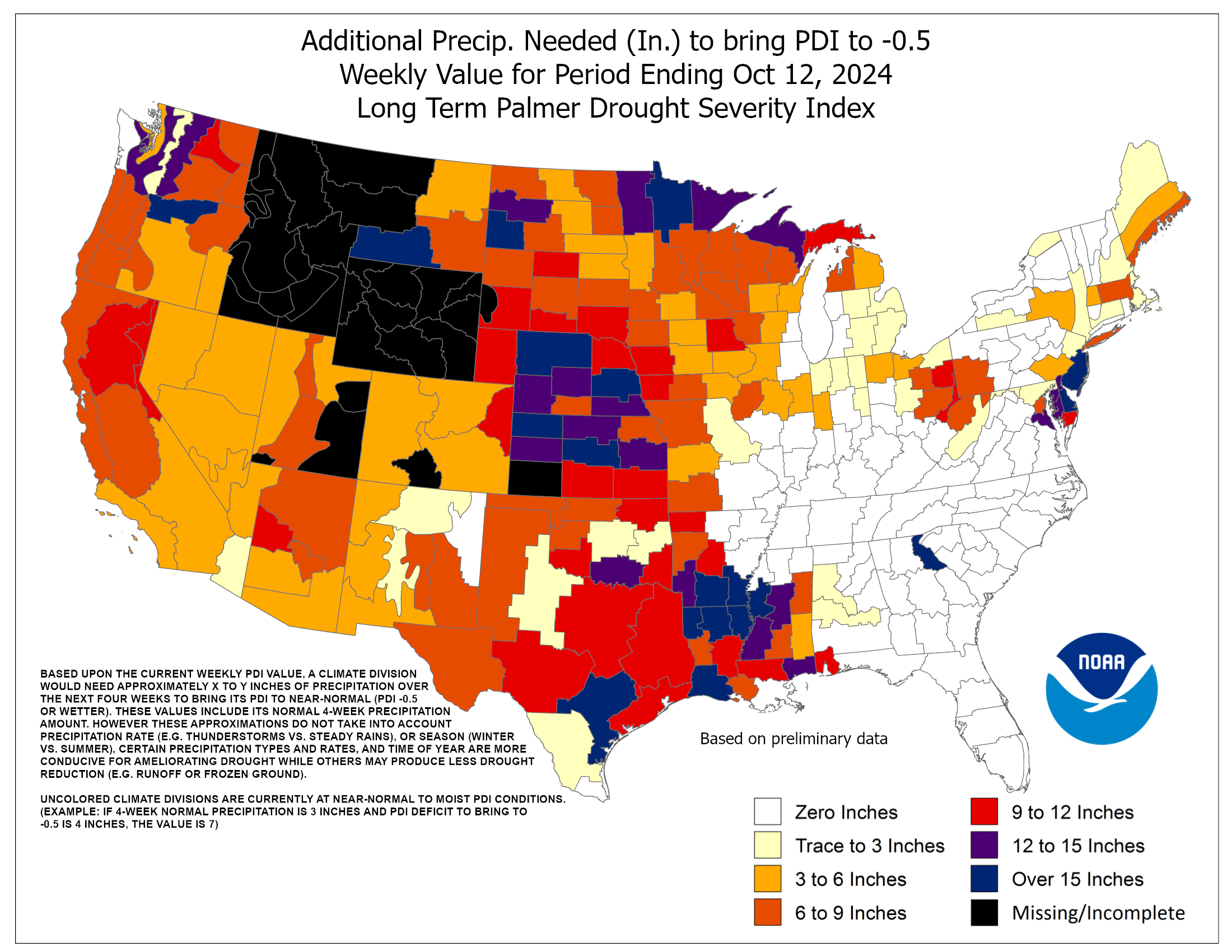
Hurricanes get a lot of attention because of the billions in damage they cost, and the lives they disrupt. AIR Worldwide estimated today that insured damage from Isaac would cost up to $2 billion. This does not include damage to infrastructure or uninsured damage, so the final price tag of Isaac’s rampage will be more like $3 – $5 billion. However, Isaac is now dumping beneficial rains over Arkansas, Missouri, Illinois, Indiana, Ohio, and Kentucky–regions stricken by the worst drought since the 1950s or 1930s, depending upon the exact location. These regions need 9 – 18 inches of rain to pull them out of drought. Isaac’s 3 – 6 inches of rain will not end the drought, but will put a pretty good dent in it. I expect that 3 – 6 inches of rain for a wide swath of prime agricultural land in extreme drought is probably worth at least $5 billion, when you consider that a recent estimate by a Purdue economist put the cost of the great drought of 2012 at more than $77 billion. Only Hurricane Katrina ($146 billion) and the drought of 1988 ($78 billion) have been more expensive disasters, according to NOAA’s National Climatic Data Center. Unfortunately, Isaac’s arrival is poorly timed, as the storm is arriving during harvest season. The strong winds associated with the storm will flatten many crops, making it more difficult to harvest them, and Isaac’s winds may cost farmers several hundred million dollars due to unharvestable crops. Still, the rains from Isaac will be highly beneficial for the success of the upcoming winter wheat season, and for next year’s growing season.


Figure 2. Predicted precipitation for the five-day period ending on Tuesday evening shows that Isaac is expected to bring a large region of 3 – 6 inches of rain (red, orange, and brown colors) to Arkansas, Missouri, Illinois, Indiana, Ohio, and Kentucky. Image credit: NOAA/HPC.


Figure 3. The great drought of 2012 has brought so little rain to the Midwest that some areas require over 15″ of rain (dark purple colors) to end the drought. Image credit: NOAA/CPC.

Unanswered questions about Hurricane Isaac

1. Did the passage of Hurricane Isaac stir up oil from the Deepwater Horizon oil spill? Isaac was the first hurricane to pass over the site of the 2010 Deepwater Horizon oil spill. We know that large hurricanes are capable of creating currents in deep water at the bottom of the Gulf of Mexico; Hurricane Ivan caused upwelling currents of 0.5 cm/s at a depth of about 500 meters. In an August 28 article in the Huffington Post, Nick Shay, professor of meteorology and physical oceanography at the University of Miami, said: “Winds will push water away from the center of a storm, which causes an upwelling as the ocean tries to adjust. It brings whatever is near the bottom up higher in the water column and currents can then push it towards the coast.” Up to 1 million barrels of oil from the spill are estimated to still be present in the deep water sediment, on beaches, and in the marshes of Louisiana, and it is possible some of this oil will wash up on the Gulf Coast in coming months. The storm surge of Isaac also likely flushed out oil lodged in the coastal marshes of Louisiana, but it is unknown how much of a concern this might be.

2. What’s the deal with these super-sized Category 1 and 2 hurricanes that have been hitting the U.S.? The past three landfalling hurricanes in the U.S.–Isaac (2012), Irene (2011), and Ike (2008)–have all been exceptionally large, among the top ten on record for horizontal extent of tropical storm-force winds. Each of these storms had an unusually low pressure characteristic of a storm one full Saffir-Simpson category stronger. Is this the new normal for U.S. hurricanes?

3. Did the new $14.5 billion upgrade to the New Orleans levee system cause worse flooding elsewhere? Whenever a new levee or flood control structure is created, you make someone else’s flood problem worse, since the water has to go somewhere. Where did the water was stopped by the new $1.1 billion, 1.8 mile-long Lake Borgne flood barrier on the east side of New Orleans go? Did it flow south and contribute to the overtopping of the levees near Braithwaite? Or did it go north and contribute to the 36 hours of storm surge in excess of 5′ observed along the Mississippi coast at Waveland? I posed this question to NHC’s storm surge expert Jaime Rhome, and he said it was impossible to know without doing detailed storm surge modeling studies.

4. Can only hurricanes beginning with the letter “I” hit the U.S. now? Isaac (2012), Irene (2011), and Ike (2008) are the last three hurricanes to hit the U.S. It turns out that hurricanes that begin with the letter “I” and “C” have more names on the list of retired hurricanes than any other letter (nine each.) I’m thinking Isaac will get its name retired, letting storms beginning with “I” take over sole possession of first place on the retired storms list.

Hurricane Kirk in the Central Atlantic
Hurricane Kirk intensified into a 105 mph Category 2 hurricane this morning, becoming the 2nd strongest hurricane of the 2012 Atlantic hurricane season. Hurricane Gordon was the only stronger storm; Gordon hit sustained winds of 110 mph just before reaching the Azores Islands on August 18. Kirk has probably peaked in intensity, and is about to move over colder waters and gradually decay. Kirk is not a threat to any land areas.


Figure 4. Morning satellite image of Tropical Storm Leslie.

Tropical Storm Leslie a long-range threat to Bermuda, Canada, and the U.S. East Coast
Tropical Storm Leslie formed on Thursday in the Central Atlantic. Leslie’s formation date of August 30 puts 2012 in 2nd place for earliest formation date of the season’s 12th tropical storm. Only 1995 had an earlier formation date of the season’s 12th storm. With records dating back to 1851, this year is only the second time 8 total storms have formed in August. The other year was 2004, when the first storm of the season formed on August 1 (Alex), and the 8th storm (Hermine) formed on August 29th. Satellite loops show that Leslie has a modest amount of heavy thunderstorm activity, and respectable low-level spiral bands and upper-level outflow. Conditions appear ripe to allow Leslie to intensify into a Category 2 hurricane by Sunday. Fortunately, Hurricane Kirk is weakening the ridge of high pressure to the north of Leslie, and Leslie is expected to turn to the northwest and miss the Lesser Antilles Islands. However, steering currents for Leslie are expected to collapse early next week, as Leslie gets stuck between two upper level lows. The storm will then slowly meander over the open ocean for many days, potentially threatening Bermuda. Leslie will stay stuck until a strong trough of low pressure approaches the U.S. East Coast around September 8. This trough should be strong enough to pull Leslie to the north and then northeast by September 9. At that time, Leslie may be close enough to the coast that the storm will make landfall in New England, Canada, or the Mid-Atlantic states. Leslie could also miss land entirely; this all depends upon the timing and strength of the September 8 trough of low pressure. Regardless, Leslie is expected to bring an extended period of high waves to the U.S. coast. According to NOAA’s Wavewatch III model, large swells from Leslie will reach Bermuda by Monday, and arrive along the U.S. East Coast on Tuesday. These waves will be capable of creating dangerous rip currents and beach erosion.

Portlight disaster relief charity responds to Issac
The Portlight.org disaster relief charity, founded and staffed by members of the wunderground community, are in Mississippi, helping out with Isaac relief efforts. You can check out their progress or donate to Portlight’s disaster relief fund at the portlight.org website.

from:    http://www.wunderground.com/blog/JeffMasters/article.html

Renewed Solar Activity (0901)

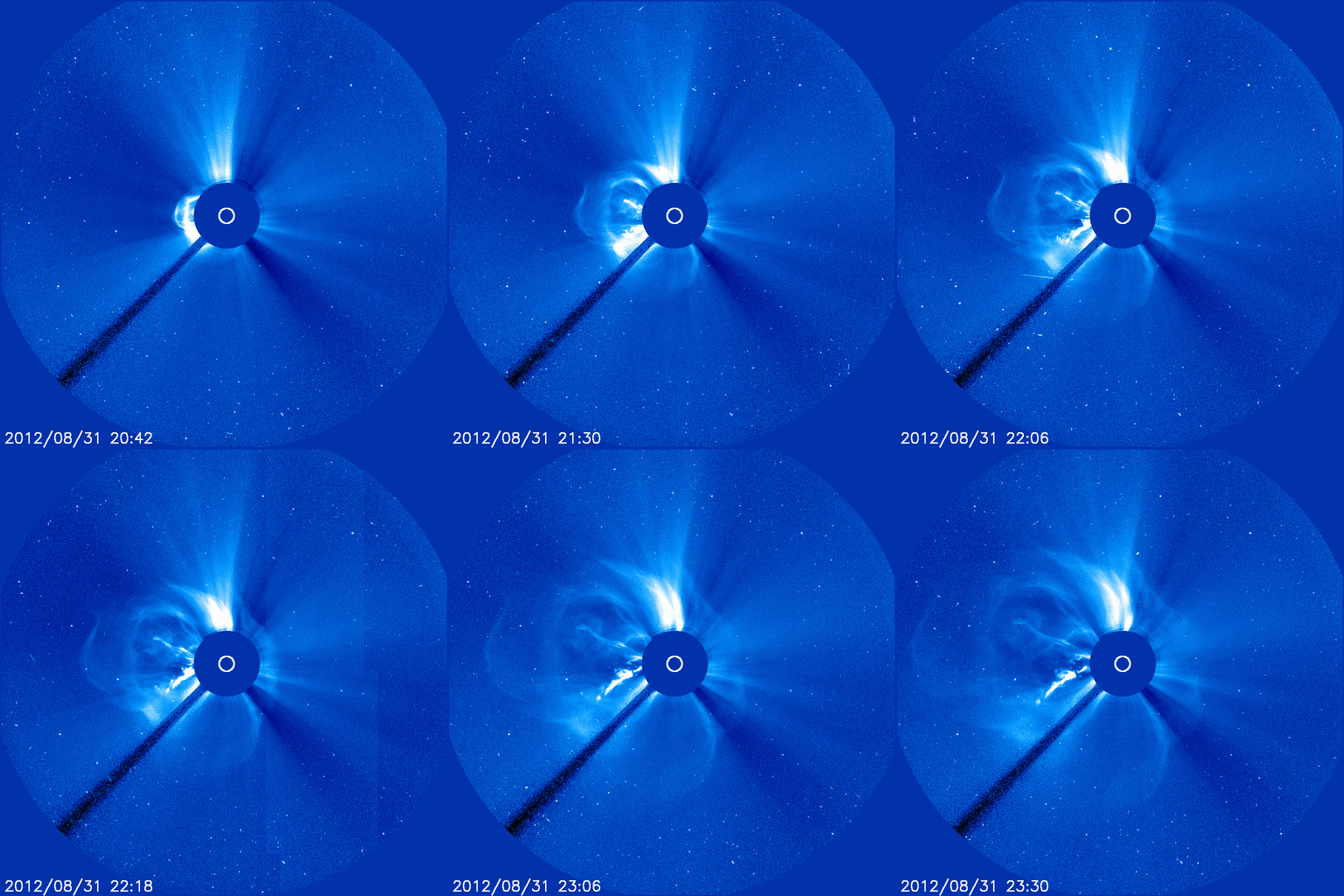
MAGNIFICENT ERUPTION: A filament of magnetism curling around the sun’s southeastern limb erupted on August 31st, producing a coronal mass ejection (CME), a C8-class solar flare, and one of the most beautiful movies ever recorded by NASA’s Solar Dynamics Observatory:

The explosion hurled a CME away from the sun traveling faster than 500 km/s (1.1 million mph). The cloud, shown here, is not heading directly toward Earth, but it could deliver a glancing blow to our planet’s magnetic field on or about September 3rd. This date is preliminary and may be changed in response to more data from coronagraphs on the Solar and Heliophysics Observatory (SOHO).

from:    spaceweather.com

August 26-September 1

Overall Color for the Week:   Indigo

Blowing your cover, that is what this week is all about, so do not be surprised if people, all of a sudden begin to look at you differently, react to you differently, step back and out of your way.  The current energies have, as they say, outed you for WHO you truly are, and you have the option of accepting and going with it, or denying and falling back into hiding.  It is you choice.  There is no judgment.  Just be sure that what you choose is what you truly desire.  Along with that, again the senses are at the forefront.  This week is all about things that you hear. Some are there, some just are.  The echoes you hear when you walk into a room, the sound of voices, conversation, movement in rooms where you find nothing.  No, you are not going crazy; rather your personal senses are becoming more attuned to the energies as they move into their new positioning.  And the hearing happens on more than one level, so you may be aware of tunes, chords, harmonies you never heard before.  Perhaps that is the Faerie coming through, or other dimensions or the rhythm of the spheres.  It is all good. Continue reading →

Re-Thinking Your Microwave Oven

June Russell’s Health Facts

Microwaves:
Microwaving — Dangers to Your Food and You

Overview

Microwave ovens are in 90% of American homes. However, the micro-oven manufacturers, Washington City politics, and plain old human nature are suppressing the facts and evidence. Because of this, people are continuing to microwave their food without knowing the effects or dangers of doing so. One short-term study found significant and disturbing changes in the blood of individuals consuming microwaved milk and vegetables. All foods that were processed through the microwave ovens caused changes in the blood of the volunteers. Hemoglobin levels decreased and over all white cell levels and cholesterol levels increased. Lymphocytes decreased.

In Dr. Lita Lee’s book, “Health Effects of Microwave Radiation – Microwave Ovens,” and in the March and September 1991 issues of Earthletter, she stated that every microwave oven leaks electro-magnetic radiation, harms food and converts substances cooked in it to dangerous organ-toxic and carcinogenic products. Micro ovens are far more harmful than previously imagined. Listed are the many findings of the German and Russian investigators. Here are just a few:

  • Cancer Causing Effects — Creation of a ‘binding effect’ to radioactivity in the atmosphere, creation of cancer-causing agents within protein hydrolysate compounds, malfunctions within the lymphatic systems, higher percentage of cancerous cells within the blood serum, cancer-causing free radicals, stomach and intestinal cancerous growths, with a gradual breakdown of the function of the digestive and excretive systems.
  • Decrease In Food Value — Microwave exposure caused significant decreases in the nutritive value of all foods researched. There was a decrease in bioavailability of B-complex vitamins, vitamin C, vitamin E, essential minerals and lipotropics in all foods, a loss of 60 to 90% of the vital energy field of all tested foods, and a marked acceleration of structural disintegration in all foods.
  • Biological Effects of Exposure — Breakdown of the human “life-energy field,” degeneration and circuit breakdowns within the front portion of the brain where thought and higher functions reside, loss of balance, long term cumulative loss of vital energy and long-lasting residual effects.

In America, neither universities nor the federal government have conducted any tests concerning the effects on our bodies from eating microwaved foods. Isn’t that odd?

Ten reasons to throw out your Microwave oven (taken from research):

  1. 1. Continually eating food processed from a microwave oven causes long term, permanent, brain damage by ‘shorting out” electrical impulses in the brain (de-polarizing or de-magnetizing the brain tissue).
  2. 2. The human body cannot metabolize (breakdown) the unknown by-products created in microwaved food.
  3. 3. Male and female hormone production is shut down and/or altered by continually eating microwaved foods.
  4. 4. The effects of microwaved food by-products are residual (long term, permanent) within the human body.
  5. 5. Minerals, vitamins, and nutrients of all microwaved food is reduced or altered so that the human body gets little or no benefit, or the human body absorbs altered compounds that cannot be broken down.
  6. 6. The minerals in vegetables are altered into cancerous free radicals when cooked in microwave ovens.
  7. 7. Microwaved foods cause stomach and intestinal cancerous growths (tumors). This may explain the rapid increased rate of colon cancer in America.
  8. 8. The prolonged eating of microwaved foods causes cancerous cells to increase in human blood.
  9. 9. Continual ingestion of microwaved food causes immune system deficiencies through lymph gland and serum alterations.
  10. 10. Eating microwaved food causes loss of memory, concentration, emotional instability, and a decrease of intelligence.

{Health Freedom Resources, Public Awareness Announcement #1, June 2000, Radiation Ovens, The Proven Dangers of Microwaves.” Also information from the Forensic Research Document, prepared by William P. Kopp, A.R.E.C. Research Operations. TO61-7R10/10-77F05. Written by Anthony Wayne and Lawrence Newell. healthfree.com, Apr. 2003}  Editor’s comment: The use of artificial microwave transmissions for subliminal psychological control, ‘brainwashing,’ has also been proven. Clinical experiments have been written up by Drs. Luria and Perov.


Microwave cooking is an important cause of ill health, and its effects are mostly ignored. The violent change that microwaving causes to the food molecules forms new life forms called radiolytic compounds, which are mutations that are unknown in the natural world. Ordinary cooking also causes the formation of some radiolytic compounds, but microwaving cooking causes a much greater number. This then causes deterioration in your blood and immune system. In addition, it was found that the number of leukocytes increases after eating microwaved food, something which hematologists take very seriously because this is often a sign of highly harmful effects, such as poisoning. Cholesterol levels increase after eating microwaved foods. In summary: Blanc and Hertel found that eating microwaved food: increases cholesterol, increases white blood cell numbers, decreases red blood cell numbers, and causes production of radiolytic compounds (compounds unknown in nature).  Editor’s comment: For those who are interested, there is a long list of effects from microwaves observed by Russian forensic teams.

I see clients for sessions of kinesiology (muscle testing), and correct the problems I find. I found that when ‘fixing’ or ‘correcting’ the electrical circuits of those who ate microwaved foods, they soon were out of balance again. However, this was not true of those who did not eat microwaved food. I gave this a higher priority than any of the things that are normally considered as health risks, such as alcohol or cigarettes. I began to tell my client on the first visit that under NO circumstance were they to ever do microwaved cooking again. David Bridgman, a kinesiologist with many years experience said, “Of all the people I test for allergies, so far 99.9% show severe sensitivity to any microwaved food.” Be aware that many restaurants use microwaved cooking, even ‘health food’ restaurants. Some of the information from this Web site on microwaved food is published in an eight volume lawyer’s encyclopedia which is used by lawyers who sue in medical cases. Some of this can be seen this Web site for those who are interested. Also much of the information on this Web site is from the 1994 edition of Acres magazine, USA, by Tom Valentine. Information on irradiated foods and labeling laws may be found at Public Citizen – www.citizen.org. Irradiation is not the same as microwaving, but they are similar in that both use unnatural frequencies to alter food.

Our society runs pretty much on money, and there is no money in telling people to stop using microwave cooking. The multinational companies who make microwaves make a lot of money from the sale of microwave ovens. There is, however, the satisfaction and happiness from knowing that you are saving people’s lives by spreading the word to stop eating microwaved foods.
{“Microwave Cooking is Killing You!” by Stephanie Relfe, B.Sc. (Syd.) on www.relfe.com/microwave.html, 2003}

for more information, go to:    http://www.jrussellshealth.org/microwaves.html


Dangerous Earthquake — Phillipines

Massive earthquake hits Philippines with tsunami warning – 1 dead

Last update: August 31, 2012 at 3:26 pm by By

Most important Earthquake Data:
Magnitude : Mw7.6 (USGS), Ml7.7 (PHIVOLCS)
UTC Time : 31st August, 2012 – 12:47:34 UTC

Local time at epicenter : 31st August, 2012 – 20:47:34 UTC
Depth (Hypocenter) :  34.9 km (USGS), 10km (PHIVOLCS)
Geo-location(s) : 96km (60mi) E of Sulangan, Philippines

Phivolcs was predicting:-

Intensity 7 in Guian, Oras, Sulat, Borongan City, Eastern Samar;

Intensity 6 in Siargao, Surigao del Norte; Tacloban City; Palo Leyte; Saint Bernard, S. Leyte;

Intensity 5 in Mati City; Compostela; Compostela; Legaspi City; Iloilo City; Beilig City; Iligan City;

Intensity 4 in Butuan City, Catbalogan City, Butuan  City, Cagayan De Oro City;

Intensity 3 in Cotabato City, Mambajao, Camiguin, General Santos City; and

Intensity 2 in Marawi, Sipalay City

UPDATE:- NDRRMC is expecting damage from an earthquake of this size, but still waiting on more damage reports.

1 person has been killed through a house collapse in Southern Cagayan de Oro city on the South Island of Mindanao killing a 54-year-old woman and injuring her 5-year old grandson.

The center in Philippines said that very small tsunami waves of 3 centimeters meters (just over an inch) were recorded along the eastern Philippine coast near Legazpi city and another nearby location indicating a possible escape from a major tsunami.

The quake knocked out power in several other towns and cities across the central and southern Philippines, though it was restored in some areas later Friday.

SUMMARY:- A massive earthquake has hit off the East coast of the Philippines. It has been felt up to an intensity VII onshore through USGS.

The tsunami was due to hit Eastern Samar Island and also the following other locations –  Northern Samar, Leyte, Southern Leyte, Surigao del Norte, Surigao del Sur. It was due to have hit already and we are waiting on reports.

The latest PTWC ratings:- Only a local tsunami warning was enforced. Eyewitness reports in the east have seen 1.2m waves.

 SEA LEVEL READINGS CONFIRM THAT A TSUNAMI WAS GENERATED. THIS  TSUNAMI MAY HAVE BEEN DESTRUCTIVE ALONG COASTLINES OF THE REGION  NEAR THE EARTHQUAKE EPICENTER. AUTHORITIES IN THE REGION SHOULD  TAKE APPROPRIATE ACTION IN RESPONSE TO THIS POSSIBILITY. THIS  CENTER WILL CONTINUE TO MONITOR SEA LEVEL GAUGES NEAREST THE  REGION AND REPORT IF ANY ADDITIONAL TSUNAMI WAVE ACTIVITY. THE  WARNING WILL NOT EXPAND TO OTHER AREAS OF THE PACIFIC UNLESS  ADDITIONAL DATA ARE RECEIVED TO WARRANT SUCH AN EXPANSION.

 FOR AFFECTED AREAS - WHEN NO MAJOR WAVES ARE OBSERVED FOR TWO  HOURS AFTER THE ESTIMATED TIME OF ARRIVAL OR DAMAGING WAVES HAVE  NOT OCCURRED FOR AT LEAST TWO HOURS THEN LOCAL AUTHORITIES CAN  ASSUME THE THREAT IS PASSED. DANGER TO BOATS AND COASTAL  STRUCTURES CAN CONTINUE FOR SEVERAL HOURS DUE TO RAPID CURRENTS.
 AS LOCAL CONDITIONS CAN CAUSE A WIDE VARIATION IN TSUNAMI WAVE  ACTION THE ALL CLE

for more information and updates, go to:   http://earthquake-report.com/2012/08/31/massive-earthquake-hits-philippines-with-tsunami-warning/


Biological Dentistry

How to Find a Biological Dentist that Can Treat You Holistically

August 25 2012

Story at-a-glance

  • About 50 percent of dentists in the US are mercury-free. However, only an estimated 10 percent of those fully understand the health risks associated with dental amalgam. It’s crucial to understand these risks when removing amalgams, or you could risk acute toxicity from the mercury released during the removal process
  • Biological dentists, also known as holistic, or environmental dentists, operate according to the belief system that your teeth are an integral part of your body and hence your overall health, and recognize that your oral and dental health can have a major influence on other disease processes in your body
  • Amalgam is a major source of environmental mercury pollution. Dental offices must be equipped with mercury separators to elimninate further mercury contamination of our environment
  • Resources for finding a qualified biological dentist are included. You’re encouraged to ask questions of your dentist prior to enlisting his services, to make sure the office is truly adhering to holistic dental practices. A dozen questions are offered as a starting point


By Dr Mercola

About 50 percent of dentists in the U.S are mercury-free However, only an estimated 10 percent of those fully understand the health risks associated with dental amalgam—half of which is toxic mercury, despite what the misleading term “silver filling” might lead you to believe

It’s crucial to understand these risks when removing and replacing amalgam “silver” fillings, or you could risk acute toxicity from the mercury released during the removal process I can testify to these risks first-hand, as I suffered kidney damage as a result of improper amalgam removal in the mid-90’s by an otherwise qualified and competent dentist Still today, two decades later, I struggle with some kidney challenges

So please, do take this advice seriously

Dr Bill Glaros is a practicing biological dentist based in Houston, Texas He’s a former president of the International Academy of Biological Dentistry and Medicine (IABDM), and he’s also an accredited member of the American Naturopathic Medical Association

He has testified before the FDA about the health risks of dental amalgam, and in this interview, he offers helpful advice on how to find a qualified biological dentist who can safely remove amalgam fillings

What is Biological Dentistry?

Biological dentists, also known as holistic, or environmental dentists, operate according to the belief system that your teeth are an integral part of your body and hence your overall health, and recognize that your oral and dental health can have a major influence on other disease processes in your body Any medical treatment performed takes this fact into account The primary aim of holistic dentistry is to resolve your dental problems while working in harmony with the rest of your body

I recommend using a biological dentist for all your dental needs, but if you’re considering removing dental amalgams, it’s an absolute necessity Most conventional dentists simply do not have the know-how to do it without putting your health at risk in the process For example, some things that need to be done to keep you safe during amalgam removal include:

  • Providing you with an alternative air source and instructing you not to breathe through your mouth
  • Using a cold-water spray to minimize mercury vapors
  • Putting a dental dam in your mouth so you don’t swallow or inhale any toxins
  • Using a high-volume evacuator near the tooth at all times to evacuate the mercury vapor
  • Washing your mouth out immediately after the fillings have been removed (the dentist should also change gloves after the removal)
  • Immediately cleaning your protective wear and face once the fillings are removed
  • Using room air purifiers

Additional or alternative precautions may also be used For example, Dr Glaros uses a saliva ejector beneath the dam along with a mercury vapor sniffer in his practice, as he’s found that the mercury vapors have a tendency to migrate underneath the dam He also stresses the importance of making sure your bladder and bowels are healthy prior to getting the work done

“There are some other issues that can happen before you start the dental part, and that would be nutritional support and making sure that people’s exit routes are open – their bladder and bowels are functioning –because it’s easier to get it out of the mouth than it is to get out of the body Getting it out of the body is the main goal It doesn’t do it by itself easily for some people,” he explains

Interestingly, certain bacteria in your gut, such as Candida, actually tries to demethylate the mercury it comes across Methyl mercury is the more hazardous type of mercury, in terms of toxicity According to Dr Glaros, some people who struggle with Candida may actually owe the troublesome bacteria a debt of gratitude, because the reason they can’t get rid of it is because your body is using it to demethylate the mercury, which decreases or limits the toxicity they’d otherwise be experiencing

Checking Compatibility of Dental Materials—An Important Step in Biological Dentistry

“One of the things that we believe in biological dentistry is it’s important to check for the compatibility of dental materials,” Dr Glaros says “There are different ways to do that I don’t care which way it’s done; I just like that it’s paid attention to That is the way to honor a patient We all have patients that can take anything Then we all have patients for whom everything becomes an issue So testing for compatibility of materials is crucial

[W]e also want to protect the environment Having mercury separators in dental offices is a unique thing, unfortunately But dentists don’t see that as an issue It’s not particularly expensive, you know, 500 bucks maybe to put a separator in your office, so that the mercury fillings you’re grinding out and cleaning out don’t end up in our water supply ”

According to Dr Glaros, an estimated 30 tons of mercury are placed in people’s mouths each year in the US That’s A LOT of mercury! And a lot of it ends up as environmental pollution as a result of dentists who fail to give this issue the attention it deserves

“San Francisco Bay had a big problem with mercury in it They tried to get the dentists to volunteer to put the separators on They didn’t do it, so they mandated it Within four or five years, the problem has cleared up in San Francisco Bay,” Dr Glaros says

Beware of Root Canals

Root canals are particularly troublesome, and a number of diseases can be traced back to individual root canaled teeth Sadly, the vast majority of dentists are oblivious to the serious potential health risks they are exposing their patients to, risks that persist for the rest of their patients’ lives The American Dental Association

for more info and video links, go to:    http://articles.mercola.com/sites/articles/archive/2012/08/25/biological-dentistry.aspx?e_cid=20120825_DNL_artNew_1

Jeff Masters on TS Isaac, TS Kirk, & New Development

Isaac slamming Gulf Coast with damaging floods, tornadoes

Published: 4:44 PM GMT on August 30, 2012

Slow-moving Tropical Storm Isaac continues to hammer coastal Louisiana, Mississippi, Alabama, and Florida’s Panhandle with tornadoes, torrential rains, high winds, and a damaging storm surge. Over the past 24 hours, destructive tornadoes have touched down in Biloxi and Pascagoula, Mississippi, and one person was killed by a tree falling on a car in Pearl River County, Mississippi. A major flood event is occurring in Slidell, Louisiana, where Isaac’s storm surge filled Bayou Bonfouca and the W-14 Canal, inundating portions of the city with 1 – 5 feet of water. While Isaac is now a weakening minimal-strength tropical storm, it is still a potent rainmaker, and will cause damaging floods all along its path for the next three days. Major river flooding is occurring or is about to occur on a number of rivers in the landfall area. In north central Tangipahoa Parish in southeast Louisiana and southwestern Pike County in southern Mississippi, a mandatory evacuation has been ordered for all low-lying areas and along the Tangipahoa River, due to the potential failure of the Lake Tangipahoa dam. Audubon Park in New Orleans, recorded 19.30″ of rain as of 7 pm Wednesday night, and 18.7″ of rain in a 24-hour period. This is the greatest 24-hour rainfall event at any official New Orleans site, with weather records extending back to 1871, according to wunderground’s weather historian, Christopher C. Burt. A few other rainfall totals from Isaac, through 11 am EDT on Thursday:

15.02″ Marion, MS
10.09″ Hattiesburg, MS
10.15″ Gulfport, MS
9.80″ Slidell, LA
9.74″ Biloxi, MS
8.52″ Mobile, AL
5.57″ Baton Rouge, LA


Figure 1. Isaac’s winds and storm surge overcomes the seawall and floods South Beach Boulevard in Waveland, Miss., Wednesday, Aug. 29, 2012, the seventh anniversary of Hurricane Katrina hitting the Gulf Coast. (AP Photo/Rogelio V. Solis). Waveland experienced a storm surge in excess of 5′ for 36 hours.

Isaac’s storm surge winds down
Storm surge levels along the coast of Mississippi and surrounding areas are gradually receding, and the surge has finally fallen below 5′ at Waveland, which experienced a storm surge in excess of 5′ for 36 hours. Isaac’s storm surge levels were characteristic of a Category 2 hurricane, and lasted for an exceptionally long period of time. Waveland, Mississippi experienced a peak surge of 8′ and peak storm tide of 9′ (surge plus the natural high tide), which beat the levels that occurred during Category 2 Hurricane Gustav of 2008 (7′ of storm tide.) The peak 11.06′ storm surge at Shell Beach, which is in Lake Borgne, 30 miles southeast of New Orleans, exceeded the 9.5′ surge recorded there during Gustav. According to an article in nola.com, Isaac pushed a storm surge of 13.6′ into Lake Borgne, on the east side of New Orleans. This is not far from the 15.5′ storm surge Hurricane Katrina brought to the location. It is quite possible that Isaac’s storm surge might have breached levees of the east side of New Orleans, flooding areas inhabited by tens of thousands of people, had the Army Corps of Engineers not completed their $14.5 billion upgrade to the New Orleans flood defenses this year. I estimate that storm surge damage from Isaac will exceed $2 billion. Isaac has likely caused $2.5 billion in insured damage not related to flooding, insurance firm Eqecat estimated yesterday. Here were some of the peak storm surge values that were recorded at NOAA tide gauges during Isaac:

11.1′ Shell Beach, LA
8.0′ Waveland, MS
3.5′ Pensacola, FL
4.6′ Pascagoula, MS
3.8′ Mobile, AL


Figure 2. A TRMM satellite 3-D view of rainfall on Aug. 28 showed a few very powerful thunderstorms near Isaac’s eye were reaching heights of almost 17 km (10.6 miles.) Intense bands of rain around Isaac were occasionally dropping rain at a rate of over 2.75 inches per hour. Image credit: SSAI/NASA, Hal Pierce.

Isaac’s storm surge on the Mississippi River
A storm surge estimated at 12′ moved up the Mississippi in Plaquemines Parish near Port Sulphur, LA, near 8:30 pm EDT Tuesday, causing overtopping of the levees and flooding of homes in the mandatory evacuation areas behind the levees. These levees were not part of the $14.5 billion levee upgrade New Orleans got after Hurricane Katrina, and were not rated to Category 3 hurricane strength, like the levees protecting New Orleans are. Since salt water is more dense than fresh water, the surge travelled along the bottom of the river, with the fresh water flow of the river lying on top. The surge continued upriver, and before reaching New Orleans, encountered an underwater barrier in Plaquemines Parish. This barrier was constructed by the Army Corps of Engineers beginning on August 15, in order to keep salt water from moving upstream and contaminating drinking water for Plaquemines Parish and New Orleans. Salt water had made it 90 miles upriver to the outskirts of New Orleans, due to the low flow rate of the river (which had dropped 7′ below average in height due to the drought of 2012.) According to a spokesperson for the National Weather Service River Forecast Office, this barrier was probably able to completely block the flow of salt water upriver due to Isaac’s storm surge, and no salt water made it as far as New Orleans. However, the massive intrusion of ocean water into the river channel caused the mighty Mississippi’s fresh water flow to back up for hundreds of miles. Water levels were elevated by 10′ in New Orleans (103 miles upstream from the mouth of the Mississippi), 8′ in Baton Rouge (228 miles upstream), and 1.4′ at Knox Landing, an amazing 314 miles upstream.

Hurricane Kirk in the Central Atlantic
Hurricane Kirk intensified into a 75 mph Category 1 hurricane this morning, becoming the busy 2012 Atlantic hurricane season’s fifth hurricane. With the season’s mid-point of September 10 still almost 2 weeks away, we’ve already had 12 named storms and 5 hurricanes, which is close to what an entire season experiences in an average year (11 named storms and 6 hurricanes.) Kirk should stay well out to sea and not trouble any land areas.


Figure 3. Morning satellite image of Hurricane Kirk.

Tropical Depression Twelve forms in the Central Atlantic
Tropical Depression Twelve has formed in the Central Atlantic, and appears destined to become a hurricane before the week is out. Fortunately, Hurricane Kirk is weakening the ridge of high pressure to the north of TD 12, and the storm is expected to turn to the northwest and miss the Lesser Antilles Islands. In the long term, it remains unclear if TD 12 will follow Kirk and fully recurve out to sea. The latest run of the GFS model predicts TD 12 will recurve out to sea and not threaten any land areas, but the latest run of the ECMWF model predicts that the trough of low pressure pulling Kirk to the norhteast will not be strong enough to recurve TD 12 out to sea. Instead, the ECMWF predicts that a ridge of high pressure will build in early next week, forcing TD 12 more to the northwest, making the storm a potential threat to Bermuda, the Northeast U.S., and Canada.

from:    http://www.wunderground.com/blog/JeffMasters/article.html

August 31 — Blue Moon

Watch Out for the Blue Moon

August 29, 2012:When someone says “Once in a Blue Moon,” you know what they mean:  Rare, seldom, even absurd.

This year it means August 31st.

For the second time this month, the Moon is about to become full.  There was one full Moon on August 1st/2nd, and now a second is coming on August 31st.  According to modern folklore, whenever there are two full Moons in a calendar month, the second one is “blue.”

Cue up the Elvis records! “Blue Moon…. You saw me standing alone, without a dream in my heart, without a love of my own.” In song and literature, blue moons have long symbolized lost love and melancholy. Elvis set the standard for lunar heartbreak in his 1956 pop hit “Blue Moon.”

Watch Out for the Blue Moon (splash)

A new ScienceCast video explores the facts and myths of Blue Moons. Play it

But will the moody Moon of August 31st actually turn blue?  Probably not.

Most Blue Moons look pale gray and white, indistinguishable from any other Moon you’ve ever seen.  Squeezing a second full Moon into a calendar month doesn’t change the physical properties of the Moon itself, so its color remains the same.

With that caveat in mind, however, be aware that on rare occasions it can happen.

A truly-blue Moon usually requires a volcanic eruption. Back in 1883, for example, people saw blue moons almost every night after the Indonesian volcano Krakatoa exploded with the force of a 100-megaton nuclear bomb. Plumes of ash rose to the very top of Earth’s atmosphere, and the Moon … it turned blue!

Watch Out for the Blue Moon (plume, 200px)

Smoke from volcanoes and forest fires can cause the Moon to turn blue. [Blue Moon Stories]

Krakatoa’s ash was the reason. Some of the plumes were filled with particles 1 micron wide, about the same as the wavelength of red light.  Particles of this special size strongly scatter red light, while allowing blue light to pass through. Krakatoa’s clouds thus acted like a blue filter.

People also saw blue-colored Moons in 1983 after the eruption of the El Chichon volcano in Mexico. And there are reports of blue Moons caused by Mt. St. Helens in 1980 and Mount Pinatubo in 1991.

Certain forest fires can do the same trick.  A famous example is the giant muskeg fire of Sept. 1953 in Alberta, Canada.  Clouds of smoke containing micron-sized oil droplets produced lavender suns and blue Moons all the way from North America to England.

There are plenty of wildfires burning in the hot, dry USA this month.  If any of them produce smoke with an extra dose of micron-sized particles, the full Moon might really turn blue.

On the other hand, maybe it will turn red.  Often, when the moon is hanging low, it looks red for the same reason that sunsets are red.  The atmosphere is full of aerosols much smaller than the ones injected by volcanoes.  Measuring less than a micron in diameter, these aerosols scatter blue light, while leaving the red behind. For this reason, red Blue Moons are far more common than blue Blue Moons.

Sounds absurd? Yes, but that’s what a Blue Moon is all about. Step outside at sunset on August 31st, look east at the moonrise, and see what color presents itself.
Author: Dr. Tony Phillips| Production editor: Dr. Tony Phillips | Credit: Science@NASA

from:    http://science.nasa.gov/science-news/science-at-nasa/2012/29aug_bluemoon/

Arctic Earthquake

Mw6.6 earthquake hits Jan Mayen in the Arctic with some damage

Last update: August 30, 2012 at 3:25 pm by By

Most important Earthquake Data:

Magnitude : Mw6.6
UTC Time : 13:43:24 UTC on August 30th, 2012
Local time at epicenter : 12:43:24 UTC on August 30th, 2012
Depth (Hypocenter) : 8km
Geo-location(s) : 93km NW away from Olonkinbyen, Svalbard and Jan Mayen

There has been reports of some damage and a rockslide, but no injuries among the 44 people living there.

A M5.2 aftershock also hit around 8 mins after the mainshock.

UPDATE:- This is reported to be one of the largest Norwegian earthquakes on record.

In 2008, a M6.2 was reported in Svalbard.

According to NORSAR “The largest earthquakes in historical times in Norway and surrounding offshore areas occurred in the Rana region in 1819, M 5.8, in the Vøring Basin in 1866, M 5.7, in the outer Oslofjord in 1904, M 5.4 and in the Viking Graben in 1927, M 5.3. The last earthquakes above M 5 include an M 5.3 event in the Vøring Basin in 1988, in an area with almost no earlier seismicity, and an M 5.2 event in the northeastern North Sea in 1989.”

The Oslofjord earthquake of 1904 is the best known earthquake causing damage in Norway.

So it looks like another earthquake record has been broken – as will continue to occur as better recording of earthquakes through time continues worldwide leading to better hazard maps in the future.

Further damage is yet to be confirmed as well as a possible tsunami caused by underwater landslide.


Beerenberg Volcano – over 2200m above sea level (Wiki Commons) – erupted in 1970 and 1985.

SUMMARY:-

A major earthquake has hit off Jan Mayen Island in Norway in the Arctic Ocean.

The Amazing coastline of Jan Mayen with the Beerenberg Volcano

44 people currently live on the small island of which the main export is gravel and also doubles as a telecommunications base for Norway.

from:    http://earthquake-report.com/2012/08/30/mw6-6-earthquake-hits-jan-mayen-in-the-arctic-with-some-damage/


El Salvador Earthquake — Effects

Strong wave destroys turtle eggs following earthquake in El Salvador

Last update: August 30, 2012 at 3:04 pm by By

A strange set of earthquake data occurred following the El Salvador earthquake a few days ago with various agencies giving very different magnitudes for the event.

A tsunami alert was also triggered and then was cancelled.

We have brief reports that have encircled the globe that the following damage occurred due to 3 strong waves after the earthquake:

– A Zoological foundation has said that 3 waves up to 3m high (not 8m as stated in some reports) washed onshore and destroyed around 45000 just hatched turtle eggs. This is around 6% of the total endangered eggs saved in the last 1.5 years. These were all of the Ridley turtle variety which is very much endangered. It also destroyed the hatcheries for turtle protection.

– The tsunami waves washed up on about 150 people collecting the eggs to protect them in special pens

– The waves injured 6 of the people who were all saved.

– No other reports of damage or a felt tsunami have been made. The earthquake was barely felt in El Salvador.

– Over 200 aftershocks have since been registered.

Kemps Ridley Sea Turtle (Wikipedia Commons)

Most important Earthquake Data:
Magnitude : Ml6.7 (SNET), Mw7.3 (USGS)
UTC Time : 04:37:20 UTC  on the 27th August, 2012
Local time at epicenter : 22:37:20 on the 26th August, 2012
Depth (Hypocenter) : 51km (SNET), 20.3km (USGS)
Geo-location(s) : 110km from the South coast of El Salvador

from:    http://earthquake-report.com/2012/08/30/strong-wave-destroys-turtle-eggs-following-earthquake-in-el-salvador/