Several journalists and content creators have noticed that Australia looks like the most totalitarian police state that has existed in recent history. It has become a full-scale pilot test for the elitists to see how well they can implement the New World Order.
Australians have been subjected to some of the most horrendous basic human rights and dignity violations during this entire scamdemic.
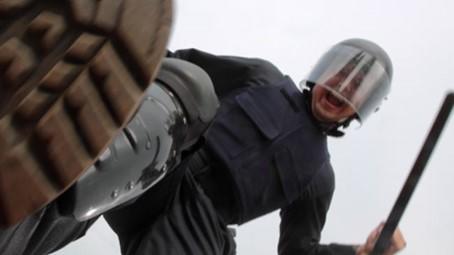
The elitists are using Australia to test out these authoritarian measures, such as getting the public used to a police state in which the military and police both patrol the streets ready to commit violence against other humans for refusing to quarantine when not sick or not wearing their New World Order issued muzzle…I mean, face mask.
“These guys know full well what they are doing. They are psychopaths, but they aren’t stupid,” says Brian in the above video. The politicians are redistributing both wealth and power away from the public and consolidating it into their own hands. We are in big trouble if we cannot get the military and the police who are committing violence on behalf of the tyrants to realize what they are doing to humanity.
All of this is over 17 new cases of COVID-19. This absolutely horrifying that people continue to buy this scam.
“Heavy-handed tyranny and oppression is happening everywhere,” Brian adds.
If you don’t think this is coming back to the United States in the form of a second lockdown, think again. The media has been preparing us for a “dark winter” and a “second wave” since the first false wave happened.
Wake up. Time is now extremely short. If you don’t have food or water, now is the time to get what you can. If you don’t have emergency plans, now is the time to make some with your family. If you are already well prepared for any disaster, the best thing you can do is to stay alert and fearless. Don’t live a life terrified (they enslave you with your fear), but make sure you know what’s going on. The best preparedness plan includes one of awareness of this situation we’ve found ourselves in today.
During 1939 two extremely open-minded and dedicated men spent a great deal of time trying to come to grips with what one of those men, Frederic Slater, President of the Australian Archaeological and Education Research Society, claimed to be Australia’s “Stonehenge.”[1] Countless hours were spent measuring and drawing a huge variety of stone arrangements, alignments and engravings placed above and beside a series of “terraces”[2] and “mounds.”[3]
This ancient complex, according to Slater, formed “the basis of all knowledge, all science, all history and all forms of writing, which began in numeration.”[4]
Figure 1: Computer generated image of Standing Stones[5]
Our initial tasks are simple: examine and assess the work and notes of Slater and his colleague and compare this to available archaeology and geography, oral testimonies of Original and non-Original people past and present, and as always, consult with Original Elders and Custodians before embarking upon such a daunting investigation.
We also intend to pick up from where the two men left off. First and foremost it would seem Slater’s recommended next target, the smaller 70 metre mound, is deserving of discreet excavation. Consisting of material foreign to the region, Slater claimed that the nearest site able to cater for the sandstone tonnage on site is “14 miles” away.[6] If he is correct, questions relating to extraction, metal blades and transportation in a land of sticks and stones technology need to be addressed
What is a little more problematic is proving or refuting in absolute terms whether Slater was correct in proposing that “the mound is one of the oldest, I should say the oldest, forms of temples in the world, and dates back to the Palaeolithic age with the advent of first man.”[8] Equally, and possibly even a touch more sensational, is Slater’s belief that the most ancient of all tongues on Earth, the “Sacred Language,”[9] was first chronicled at this complex.
Figure 2: Smaller mound/burial site[7]
Just before anything could be resolved or formally investigated, the Second World War began, Government agencies pressured the landholder and the site was destroyed soon after. All discussion came to a close until mid-2013, when Slater’s correspondence was found amongst unmarked files in the local Historical Society.
Site Description
Very little, in terms of general location, specific soil types and geology, can be shared for fear that such information would betray either the position of this complex of “terraces,”[10] “mounds,”[11] “circles”[12] and “stone arrangements,”[13] or the landholders’ identity. All that can be said is that the site is quite remote and can be found within 40 kilometres of Mullumbimby NSW.
Figure 3 (Map 1): western slope of bigger mound[14]
The bigger mound is on a westerly slope and the smaller mound was built on top of a level swampy plain of black/grey loam. On parts of this flat wide plain, sugar cane is grown and the slopes that are cleared are carrying beef cattle. The alignment and distance from the ocean is known, but again sharing such information achieves nothing bar narrowing down possibilities and geography. What can be stated with absolute certainty is that this area contains no natural deposit of sandstone, while igneous rocks, some weighing hundreds of kilograms, can be found across all slopes and gullies and throughout the level paddocks.
Figure 4 (Map 2): Smaller mound and scatter of sandstone rocks[15]
On the two days we were permitted to conduct archaeology, the two mounds (see Maps 1 and 2) were of particular interest. The smaller mound, which is approximately 70 metres long and 5 metres high, seems in opposition with the surrounding landscape. There are hundreds of hectares of flat land all around, and this mound is at least 50 metres from any natural slope.
A variety of commentators had made note of the obvious artificial nature of this construction. A teacher from a nearby school, who was following up on the scant details still available in 1964, made reference to “the presence of a single mound of this type in an entire swampy flood plain, the locals say imported. So far I have not had time to carry out a profile examination, but again our geographers on staff cannot understand its presence.”[16] Even though the teacher maintained a degree of skepticism, he posed a rhetorical question that we must attempt to answer:
“How can a natural line of small sandstone pieces suddenly appear in a line and on a mound in a swamp when all surrounding rocks are igneous?” [17]
The much larger mound, which spans well over one hundred metres, was originally the place where the Standing Stones were carefully positioned and realigned throughout the year. Not only were all the stones of this construction and the many other arrangements nearby bulldozed and disc ploughed, it seems the actual mound itself was cleared of stones and ‘de-terraced.’
In one of Slater’s first letters to his on-site colleague, he not only asks “how many terraces on the mound,”[18] but reminds him if he can “ascertain the number of terraces on the hillside”[19] it would solve one of the many riddles associated with this site. He privately hoped that there were “six terraces.”[20] Further on, he requests that more investigation into the terracing be done, suggesting that if the terraces have “wavy lines”[21] it may “indicate something flowing or moving onwards.”[22]
Even though all signs of the terraces are gone, not so the displaced rocks that were on the mound. They are spread all over the slopes of the larger mound and some can be found down on the flats, over 50 metres from their original position. A large proportion of the sandstone rocks that are easily seen, seem to have worked edges, flat sides and straight lines, but bear no impact or percussion marks as would be expected if fashioned by rock tools. Apart from the two mounds and hundreds of sandstone rocks, no other stone arrangements or unusual formations are apparent.
Figure 5: Sandstone “shaped stones”[23]
to read more, go to: http://wakeup-world.com/2013/10/04/australias-stonehenge-may-re-write-world-history/
Deep harmless earthquake in the Banda Sea (Indonesia) felt until Australia
Last update: September 1, 2013 at 12:25 pm by By Ashish Khanal
Update 12:12 UTC : In our back office we are receiving from our readers almost the same MMI values from Timor (Dili) as from Australia (Darwin), althoudg the distances to the epicenter are completely different (Dili 319 km and Darwin at least 500 km)
Update 12:12 UTC : The main reason why this earthquake (although very strong but not massive) was felt at such big distances is the depth of the hypocenter. The wave bundle radiates far away from the explosion point and reaches even Australia. Scary but harmless, but always wise to consult our pages if the depth was not shallow.
The earthquake source is located in the hot solid mantle of our planet.
Update 12:12 UTC : This is how the earthquake looks like on the seismograph at Soe (Indonesian part of Timor), the islands relatively close to the epicenter
Seismogram courtesy and copyright Geofon, Germany
NO Tsunami risk for the whole region (reason : not strong enough and too deep)
319 km E of Dili, East Timor / pop: 150,000 / local time: 20:52:32.3 2013-09-01
2046 km SE of Bandar Seri Begawan, Brunei / pop: 64,409 / local time: 19:52:32.3 2013-09-01
2079 km W of Port Moresby, Papua New Guinea / pop: 283,733 / local time: 21:52:32.3 2013-09-01
Very Strong earthquake in a nearly unpopulated region of Australia
Last update: June 9, 2013 at 3:35 pm by By Ashish Khanal
Update : The earthquake was reasonably close to Yulara (about 100 km) – which had damage through an earthquake in 1989.
Update : These earthquakes are not uncommon in Northern Territory and South Australia with a similar earthquake occurring last year. Click here for more information about historic damaging quakes in Australia (CATDAT).
Update : USGS expects a very strong shaking close to the epicenter as a result of the very shallow depth of only 3,9 km. Luckily, there is no settlement with more than 1000 inhabitants.
A very strong earthquake with Magnitude 5.6 occured in the desert region near the border of South Australia and Northern Territory. This area is nearly unpopulated, so we do not expect any larger damage from this quake.
Most important Earthquake Data:
Magnitude : 5.5
Local Time (conversion only below land) : 2013-06-09 23:52:13
Last update: July 20, 2012 at 1:17 pm by By Ashish Khanal
Moderate 4.5M earthquake 117km from Canberra, Australia. A 4.5M earthquake struck 13km from Moe, Australia at a depth of 10km (USGS). This could be felt as a V (moderate shaking) around this area and as weak to light far away. We at earthquake report think this earthquake will not cause injuries or heavy damage and only light damage like fallen objects.
There have been a number of felt reports from Melbourne coming in.
The Geoscience Australia website was down momentarily.
The quake will be felt around V intensity. Seismologist at the Seismology Research Centre, Gary Gibson, has confirmed that the latest shake has been a magnitude 4 earthquake east of Thorpdale.
13km (8mi) SW of Moe, Australia 21km (13mi) W of Morwell, Australia 34km (21mi) W of Traralgon, Australia 77km (48mi) ESE of Cranbourne, Australia 114km (71mi) ESE of Melbourne, Australia
This was recorded as the largest quake in Victoria since the 1903 Warnambool events (Mb 5.3), however the 1969 event of Ml5.3 and 1982 event of Ml5.4 are also in the same ballpark. The Seismological research center of ES&S still has the earthquake recorded as an Ml5.5.
A number of foodstock losses will also occur at various supermarkets with many items being thrown off the shelves.
A number of houses have recorded damage in the form of cracks to walls, ceilings and in other concrete as well as other minor damage such as fallen tiles.
Update 13:10UTC:
Still waiting for further damage reports from the ground, with at least 25 potential instances of damage being recorded at this point through the SES. VicSES has implemented a Quake safety awareness and response program “QuakeSafe” in the past few years.
Update13:05UTC:
Residential property has sustained minor damage from the tremor. Some residential properties in Moe and some in the La Trobe Valley appeared to be the hardest hit.
“There’s been cracks in walls, damage to ceilings and windows, and possibly some building damage so far” said SES Spokesman Lachlan Quick talking to news services in Australia.
The instance of damage from further afield in Moe has brought the potential estimated damage bill to between $0.7 and 4.1 million AUD from rapid loss estimation packages but further calibration is required on the intensities from the ground before any concrete estimate can be released.
Summary13:00UTC:
– A shallow Mb5.3 earthquake struck just after 20:53 (8:53pm) local time around the Latrobe Valley at Childers, south of Trafalgar.
– Over 35 calls have been put into the Victorian SES for assistance.
– No major damage reported as yet.
– Around 7000 people live in the VI intensity area, with many more in the V intensity area.
Update12:56UTC: Anyone living in or near Childers with Internet access would be very much appreciated to submit a felt report. Thankyou to all Victorians for their responses – it really helps us to pinpoint the damage area!
Update12:50UTC: Just to show the effect of this quake around 10-12 km away from the epicenter in Trafalgar – “Have experienced lighter tremors in this area before i.e. Mid Gippsland eminating in South Gippsland Region, but this was clearly the most dramatic…. Previous ones were around 4.3. Whole house shaking with this one i.e. quite violently more of a 5 or above and accompanying strange sound/noise. All the neighbours ran out into the street afterwards. Felt at first like a sudden wind”.
From Mirboo North – “Shaking and noise lasted about 20 seconds? I have never felt anything so violent in my life.”
From Moe – “Was in the car, felt like people jumping on it. Got home stuff over the floor and cupboard doors opened.”
The seismogram at Toolangi (about 120km away)
Update12:48UTC: For people interested in the economics of the region, East Gippsland has a $1.72 billion GDP mainly due to the manufacturing and construction industry. The area affected however, is slightly west of this area, and has a capital stock of around $65 million with less than 1% damage expected, meaning that there is likely to be less than $1 million damage at this stage based on historic statistics, if any! Trafalgar used to have a cheese factory but was closed in 1990, meaning the cruel fate seen to the cheese in Italy, will not occur here.
Update12:44UTC: VICSES has recieved 35 requests for assistance so far from the broader Gippsland area and parts of metropolitan Melbourne.
Update: At least 7,000 people would be within potentially damaging area. With the main towns being Yarragon (1100+), Trafalgar (2600+) and Mirboo North (2000+) within this area. The larger towns/cities of Moe-Newborough, Morwell, Yarragul and Leongatha are far enough away to have only very slight to no damage.
Update: The quake would have been felt for around 30 seconds looking at the following seismogram of the event. The Victorian State Emergency Service (SES) have received 20 requests for assistance in the broader Gippsland area and parts of Melbourne. No significant damage has as such been recorded however. Mirboo North could also have sustained cracks in houses.
Update: It has also been felt at about Intensity V in Morwell. Childers is expected to have an intensity of VI or VII.
The local view of the epicentral area. Childers is a small rural community. Courtesy: Homesales.
Update: The epicenter was located about 10km south of the Princes Highway, the main truck and transport route around Australia.
Update: Mb5.3 as recorded by Geoscience Australia – also SW of Moe. This will cause slight damage such as broken windows and cracking in the immediate area. It has been recorded near the village of Childers near Yarragon North. This is located south of Trafalgar. Being dark given that it is winter in Australia, it will be difficult to evaluate the damage.
It should be said that the earthquake hypocenter location has not been finalised from Geoscience Australia yet.
Update: The 1922 earthquake was the last earthquake to cause damage in Victoria with a magnitude higher. Since the 1800s, there have been at least 15 damaging earthquakes in Victoria of significance, the last being in 2009. The famous Warnambool earthquakes of 1903, and the Selwyn Fault quake of 1932 have been the most famous. – CATDAT Damaging Earthquakes Database.
Update: Ml5.5, 10km depth. Residents have recorded shaking of up to 40 seconds, with some soft soils in the area meaning shaking would have been felt longer than expected for such a magnitude.
Update: USGS has the epicenter out near Trafalgar, SW of Moe. Felt reports from Trafalgar would be appreciated.
Update: The earthquake has been given as Ml5.5 by some sources. The earthquake is far enough away from power stations to not have any problems, but some local lines may be affected.
Update: Victorian Police say they have received a number of calls in relation to the tremor. They say they do not have any reports of major damage which is expected with the intensities seen. The news caused immediate panic on the internet. The Geoscience Australia website crashed as people flocked online to see what had happened. We will keep you posted.
Update : This earthquake has been felt at a V intensity at Moe-Yallourn, IV at Morwell, III in Melbourne and other areas. It is likely to have caused some minor damage near the epicenter.
Update : Moe and Latrobe Valley is a famous coalmining and electricity production industry area. In addition, they have had earthquakes recently near Mt. Baw Baw of the same magnitude in 1996, Ml5.0.
The coal mining and electricity production industry (Wiki)
Update : The epicenter is in the greater Melbourne area, very close to Trafalgar, Narracan and Moe
The earthquake is very shallow and has a Magnitude who can inflict some minor damage.
Based on the overwhelming number of reports we are receiving, a merely light top moderate shaking has been experienced by many people.
An earthquake of magnitude 5.2 occurred in the highly populated region of Victoria in Australia. The earthquake happened 5km from Trafalgar. The nearest populated places are: Mirboo North (18km), North Mirboo (18km), Boolarra (16km), Darlimurla (14km), Hallston (19km), Allambee South (14km), Delburn (10km), Thorpdale South (11km), Yinnar (14km), Childers (10km), Hazelwood (15km), Thorpdale (5km), Narracan (4km), Allambee (14km), Trafalgar South (3km), Gainsborough (20km), Cloverlea (17km), Coalville (6km), Morwell (18km), Yarragon (12km), Haunted Hills (13km), Darnum (17km), Yallourn (15km), Moe (9km), Trafalgar East (8km), Tanjil South (16km), Shady Creek (19km), Willow Grove (19km). The closest civilian airport is La Trobe Regional (25km).
Most important Earthquake Data:
Magnitude : 5.2 (USGS), 5.3 Mb (body wave magnitude) Geoscience Australia.
UTC Time : Tuesday, June 19, 2012 at 10:53:29 UTC
Local time at epicenter : Tuesday, June 19, 2012 at 08:53:29 PM at epicenter
Depth (Hypocenter) : 9.9 km USGS, 10km GA
Geo-location(s) :
for more information and updates, go to: http://earthquake-report.com/2012/06/19/strong-earthquake-in-the-greater-melbourne-area-australia/
Most important Earthquake Data:
Magnitude : 5.6 (USGS) – Ml 6.1 (Geoscience Australia)
UTC Time : Friday, March 23, 2012 at 09:25:16 UTC
Local time at epicenter : Friday, March 23, 2012 at 07:55:16 PM at epicenter
Depth (Hypocenter) : 10.7 km (6.6 miles)
Geo-location(s) :
Very close to Ngarutjara (risk area)
317 km (197 miles) SSW (213°) from Alice Springs, Australia
available
Red circle area can be damaging – image courtesy Geoscience Australia
– The earthquake’s epicentre was recorded at a shallow depth near Ernabella, 415km north west of Coober Pedy and about 320km south west of Alice Springs, just before 8pm. It is about 130km SE of Uluru.
– A magnitude of Ml6.12 has been given by Geoscience Australia. Given the remoteness it is difficult to constrain the magnitude.
-It has been given a M5.6 by other agencies.
Ernabella has an airstrip, and 2 houses.
Geoscience Australia reported the quake could have been felt by people up to 500km away and damage experienced within a 40km radius of the epicentre.
“There are a number of Aboriginal communities near the epicentre and they would have felt the earthquake strongly,” he said.
“It is possible there could be some minor damage up there.”
An SA Police spokesman said there had been no reports of damage or
injuries as yet, but being nightfall probably more information will be
found tomorrow.
Earthquake overview : A strong shallow earthquake occurred in the coastal waters of western Australia. The quake occurred in the middle of the Australian night approx. 50 km from Exmouth and the Cape Range National Park.
Update : The greater epicenter area had some similar earthquakes since 1990, most of them to the North West and all of the earthquakes at a depth less than 35 km.
Update : The Muiron Islands Nature reserveis located within the potential (light) damageradius given by Geoscience Australia
Update : All data below is from Geoscience Australia
Update : Locations where the earthquake might have been felt : Lyndon, Exmouth, Cape Range National Park, Dampier, Onslow and Yannarie
Update : Geoscience Australia expects this earthquake to be felt in a radius of 252 km
Most important Earthquake Data:
Magnitude : Mw 5.4
Local time at epicenter : Tuesday, December 06, 2011 at 04:10:03 AM at epicenter
Depth (Hypocenter) : 15 km
Geo-location(s) :
Approx. 20 km from the Muiron Islands Nature Reserve
50 km from the North West Cape
QUINOX SUNRISE: The seasons changed this morning at 5:05 a.m. EDT when the Sun crossed the celestial equator heading south. Fall began in the Northern Hemisphere, spring in the Southern Hemisphere. Geoffrey Wyatt of Sydney, Australia, woke up early to watch the equinox sun rise over Watson’s Bay:
“This is how the first day of spring began in Australia,” says Wyatt. “Recent fires in the Sydney area have contributed to redder than usual sunrises and sunsets.Temperature gradiants over the water produced the added bonus of a miraged sun.”
Tasmanian Forest Deal Brings End to a Conflict While Saving Trees
by Nicklas Karlsson | August 05, 2011
The federal Australian government has signed a deal with Tasmania which ensures the preservation of, at least, 430,000 hectars of ancient high conservation value forests.
The 430,000 hectars will be immediately protected from logging, while an additional 142,000 hectars will be set aside for eventual needs to fulfill existing logging contracts.
The conflict which has been unfolding for nearly 30 years between the federal government and state government circulates around issues of financial dependence upon logging rights. $276 million has been pledged, of which $85 million is earmarked as an exit package for forestry contractors, and some $120 million for the purpose of diversifying the economy of towns dependent on forestry over the next 15 years.